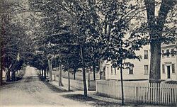
Marshfield Hills, Massachusetts
| Marshfield Hills, Massachusetts | |
|---|---|
| Census-designated place | |

Highland Street c. 1905
|
|
| Coordinates: 42°8′40″N 70°43′47″W / 42.14444°N 70.72972°WCoordinates: 42°8′40″N 70°43′47″W / 42.14444°N 70.72972°W | |
| Country | United States |
| State | Massachusetts |
| County | Plymouth |
| Area | |
| • Total | 4.9 sq mi (12.7 km2) |
| • Land | 4.5 sq mi (11.7 km2) |
| • Water | 0.4 sq mi (1.0 km2) |
| Elevation | 128 ft (39 m) |
| Population (2010) | |
| • Total | 2,356 |
| • Density | 480/sq mi (190/km2) |
| Time zone | Eastern (EST) (UTC-5) |
| • Summer (DST) | EDT (UTC-4) |
| ZIP code | 02051 |
| Area code(s) | 781 |
| FIPS code | 25-38960 |
| GNIS feature ID | 0615219 |
|
Marshfield Hills Historic District
|
|

North Community Church and the adjacent cemetery
|
|
| Location | Bow, Highland, Main, Old Main, Pleasant and Prospect Sts., Glen, Marshfield, Massachusetts |
|---|---|
| Area | 134 acres (54 ha) |
| Architectural style | Colonial, Georgian |
| NRHP Reference # | 09001096 |
| Added to NRHP | December 18, 2009 |
Marshfield Hills is a census-designated place (CDP) in the town of Marshfield in Plymouth County, Massachusetts, United States. The population was 2,356 at the 2010 census. The historic center of the village has been designated a historic district and listed on the National Register of Historic Places.
Marshfield Hills is located at 42°8′40″N 70°43′47″W / 42.14444°N 70.72972°W (42.144557, -70.729800).
According to the United States Census Bureau, the CDP has a total area of 12.7 km² (4.9 mi²), of which 11.7 km² (4.5 mi²) is land and 1.0 km² (0.4 mi²) (7.94%) is water.
As of the census of 2000, there were 2,369 people, 841 households, and 687 families residing in the CDP. The population density was 202.4/km² (524.2/mi²). There were 862 housing units at an average density of 73.6/km² (190.7/mi²). The racial makeup of the CDP was 98.27% White, 0.34% African American, 0.25% Native American, 0.34% Asian, 0.21% from other races, and 0.59% from two or more races. 0.59% of the population were Hispanic or Latino of any race.
...
Wikipedia
