Marsfield
|
Marsfield Sydney, New South Wales |
|||||||||||||
|---|---|---|---|---|---|---|---|---|---|---|---|---|---|

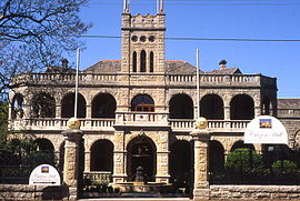
Curzon Hall on Agincourt Road, built in 1898
|
|||||||||||||
| Population | 12,347 (2011 census) | ||||||||||||
| Postcode(s) | 2122 | ||||||||||||
| Location | 16 km (10 mi) north-west of Sydney CBD | ||||||||||||
| LGA(s) | City of Ryde | ||||||||||||
| State electorate(s) | Ryde | ||||||||||||
| Federal Division(s) | Bennelong | ||||||||||||
|
|||||||||||||
Marsfield is a suburb that is part of the Northern Suburbs of Sydney, Australia. The green residential suburb is noted for its proximity to a number of leading scientific and tertiary educational institutions. Marsfield is located 16 kilometres north-west of the Sydney central business district in the local government area of the City of Ryde. Due to its close proximity to Macquarie University, the Macquarie Park Business Park, Macquarie University Hospital, Macquarie University railway station and Macquarie Shopping Centre, it is a growing suburb.
The suburb's name is derived from Field of Mars, the original name in the early days of British colonisation of Australia, given to the area by Governor Phillip in 1792 .
The whole area between the Parramatta and Lane Cove Rivers was originally known by its Aboriginal name Wallumatta. The aboriginal name survives in a local park, the Wallumatta Nature Reserve, located at the corner of Twin and Cressy Roads, North Ryde.
In 1792 Governor Phillip began the granting of parcels of lands to Royal Marines, and the area was referred to on Phillip's maps as the Field of Mars, named after the Roman Field of Mars probably because of the military link. The area was later part of the suburb of North Ryde, and many consider that Marsfield is still a part of the greater North Ryde area. Field of Mars was also the name for the parish proclaimed in 1835.
...
Wikipedia
