Marple railway station
| Marple |
|
|---|---|

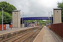
The station in 2015
|
|
| Location | |
| Place | Marple |
| Local authority | |
| Operations | |
| Station code | MPL |
| Managed by | Northern |
| Number of platforms | 2 |
| DfT category | D |
| Live arrivals/departures, station information and onward connections from National Rail Enquiries |
|
| Annual rail passenger usage* | |
| 2011/12 |
|
| 2012/13 |
|
| 2013/14 |
|
| 2014/15 |
|
| 2015/16 |
|
| Passenger Transport Executive | |
| PTE | Transport for Greater Manchester |
| History | |
| Key dates | Opened 1865 |
| National Rail – UK railway stations | |
| * Annual estimated passenger usage based on sales of tickets in stated financial year(s) which end or originate at Marple from Office of Rail and Road statistics. Methodology may vary year on year. | |
|
|
|
Marple railway station is on the Hope Valley Line and serves Marple, in the , Greater Manchester, England. It is 8.9 miles (14.3 km) south east of Manchester Piccadilly. Its three letter station code is MPL. The station, opened in 1865 by the Manchester, Sheffield and Lincolnshire Railway, was demolished and rebuilt in 1970. It is managed and served by Northern, who provide two trains per hour in each direction.
The other station serving Marple is Rose Hill railway station, on a spur of the Hope Valley Line which, until 1970, continued towards Macclesfield.
The station is located to the east of Marple, next to Marple Bridge, close to Brabyns Park and the Peak Forest Canal. The A626 runs over a bridge just next to the station and provides access to it. The next station towards Piccadilly is Romiley; the next towards Sheffield is Strines.
The station has two side platforms, each 153 yards (140 m) long; platform 2 can be accessed from the ticket office, and platform 1 only by a footbridge over the station, which can also be reached with a lift. The ticket office is staffed during the day and there are benches, toilets and a waiting room on the platform.Passenger information systems include dot-matrix displays and an automated public-address system announce approaching services. Timetable information posters are provided and help points allow passengers to contact railway staff. To the east of the station there is a free car park and the nearest bus stops are 150 metres (160 yd) away on .
...
Wikipedia
