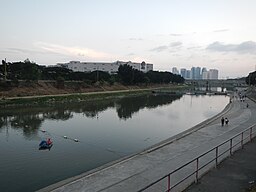
Mariquina River
| Marikina River (Ilog ng Marikina) | |
|
Marikina River in Marikina
|
|
| Country | Philippines |
|---|---|
| Regions | National Capital Region, CALABARZON |
| Cities | Marikina, San Mateo, Quezon City, Pasig |
| Source | |
| - location | Rodriguez, Rizal, CALABARZON |
| Mouth | Pasig River |
| - location | Pasig, National Capital Region |
| - elevation | 0 m (0 ft) |
| - coordinates | 14°33′30″N 121°04′05″E / 14.55833°N 121.06806°ECoordinates: 14°33′30″N 121°04′05″E / 14.55833°N 121.06806°E |
| Length | 38 km (23.61 mi) |
| Basin | 514 km2 (198.46 sq mi) |
| Discharge | |
| - average | 38 m3/s (1,300 cu ft/s) |
| - max | 54 m3/s (1,900 cu ft/s) |
|
Drainage map of the Pasig-Marikina River River system
|
|
Marikina River (Tagalog: Ilog Marikina) is a river in eastern Metro Manila, Philippines. It is a tributary of Pasig River with headwaters located in the Sierra Madre Mountains in Rodriguez, Rizal province.
Marikina River used to be an important transport route during the Spanish colonial era, but its importance as a transport route diminished when the Philippines' national highway system became more established. The resulting lack of river boat traffic and the deforestation of the upland areas in what is now the Upper Marikina River Basin Protected Landscape contributed to the river's siltation, further reducing its value as a transport route.
Due to negligence and industrial development, the river has become very polluted, an act which recent Marikina City administrations have attempted to address.
In Brgy. Wawa in Rodriguez, the Marikina River is dammed by Wawa Dam, a structure built during the early 1900s to provide water for Manila. From Rodriguez, the river flows through San Mateo then to its namesake city of Marikina. In Pasig City, the river meets the gates of the Manggahan Floodway, a controlled waterway used to prevent flooding in Manila during heavy rains by diverting most of the water of the Marikina towards Laguna de bay instead of Pasig River. Located 6.75 kilometres (4.19 mi) downstream is the confluence of Marikina and Pasig Rivers.
The river's depth ranges from 3–21 meters and spans from 70–120 meters. It has a total area of nearly 75.2 hectares and is 27 kilometers long. The riverbank has an elevation of 8 meters above sea level at the boundary of San Mateo and Marikina. This slowly goes down at an elevation of 4 meters nearly before the Malanday and Santo Niño boundary. The lowest elevation is along Calumpang which 2 meters above sea level.
...
Wikipedia


