San Mateo, Rizal
| San Mateo | |||
|---|---|---|---|
| Municipality | |||

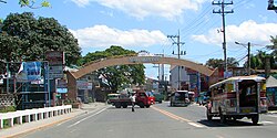
Welcome facade of San Mateo at Nangka Bridge
|
|||
|
|||
| Nickname(s): Mountain Biking Capital of the Philippines | |||
| Motto: "San Mateo, Bayan Ko, Mahal Ko" (San Mateo, My Town, My Love) |
|||
 Map of Rizal showing the location of San Mateo |
|||
| Location within the Philippines | |||
| Coordinates: 14°41′49″N 121°07′19″E / 14.69694°N 121.12194°ECoordinates: 14°41′49″N 121°07′19″E / 14.69694°N 121.12194°E | |||
| Country | Philippines | ||
| Region | CALABARZON (Region IV-A) | ||
| Province | Rizal | ||
| District | 2nd District of Rizal | ||
| Founded | February 29, 1908 | ||
| Barangays | 15 | ||
| Government | |||
| • Mayor | Cristina C. Diaz | ||
| Area | |||
| • Total | 55.09 km2 (21.27 sq mi) | ||
| Population (2015 census) | |||
| • Total | 252,527 | ||
| • Rank | 6 out of 1,489 Municipalities | ||
| • Density | 4,600/km2 (12,000/sq mi) | ||
| Time zone | PST (UTC+8) | ||
| ZIP code | 1850 | ||
| IDD : area code | +63 (0)2 | ||
| Income class | 1st | ||
| Website | www |
||
San Mateo is a first class municipality in Rizal, Philippines. It is bordered by Quezon City to the west, the cities of Marikina and Antipolo to the south, and to the north by the municipality of Rodriguez. San Mateo is approximately 24 kilometres (15 mi) east of Manila and 11 kilometres (6.8 mi) north of Pasig, the former provincial capital of Rizal.
According to the 2015 census, it has a population of 252,527 people. Conurbated to the urban agglomeration of the Greater Manila Area, San Mateo is one of the fastest growing municipalities in Rizal Province, according to the Metropolitan Manila Development Authority (MMDA) and the Provincial Government of Rizal.
The town lies in the Marikina Valley. The Marikina River runs through the western portion of the municipality, while Nangka River runs through the south, bounded by Marikina City. San Mateo has lush trees in other high areas.
The municipality has many spacious parks, tree-lined streets and roads, and industrial zones. Most of the municipality is composed of residential areas, whereas the eastern side is composed of high plateaus and foothills of the Sierra Madre Mountains.
There are 15 Barangays in San Mateo.
In his book Conquistas de las Islas Filipinas, Father Gaspar de San Agustin records the Municipality of San Mateo in 1572 as a town annexed to Pasig. He described the inhabitants as "fierce but friendly and of quiet disposition." Father Juan de Medina, in his account Relacion de los Con ventos Y Pueblos Fundados por los PP. Agustinos, likewise put 1572 as the year the Parish of San Mateo was established. However, according to Miguel López de Legazpi, the first Spanish Governor in the Philippines (1571 to 1572), it was Juan de Salcedo, his nephew who discovered the site of present-day San Mateo during one of his expeditions to Manila from Cebu. Accounts say that two years before he came to Manila from Cebu, Legazpi sent Salcedo along with 150 soldiers to prepare the inauguration of the City of Manila. It must have been Salcedo who discovered the town before Legazpi inaugurated Manila on June 24, 1571.
...
Wikipedia


