Margaretville, NY
| Margaretville, New York | |
| Middletown Center | |
| Village | |
|
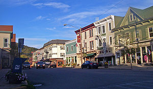
Main Street from Walnut Street to Bridge Street near NY 30
|
|
| Name origin: From Margaret Lewis | |
| Country | United States |
|---|---|
| State | New York |
| Region | Catskills |
| County | Delaware |
| Town | Middletown |
| River | East Branch Delaware River |
| Elevation | 1,316 ft (401 m) |
| Coordinates | 42°8′51″N 74°39′4″W / 42.14750°N 74.65111°WCoordinates: 42°8′51″N 74°39′4″W / 42.14750°N 74.65111°W |
| Highest point | NE corner on Kettle Hill |
| - elevation | 1,600 ft (488 m) |
| - coordinates | 42°9′11″N 74°38′19″W / 42.15306°N 74.63861°W |
| Lowest point | East Branch Delaware River at SW boundary |
| - elevation | 1,280 ft (390 m) |
| - coordinates | 42°8′15″N 74°39′29″W / 42.13750°N 74.65806°W |
| Area | 0.7 sq mi (2 km2) |
| Population | 596 (2010) |
| Incorporated | 1875 |
| Timezone | Eastern (EST) (UTC-5) |
| - summer (DST) | EDT (UTC-4) |
| ZIP Code | 12455 |
| Area code | 845 Exchange: 586 |
| FIPS code | 36-45557 |
| GNIS feature ID | 0956506 |
Margaretville is a village in Delaware County, New York, United States. The population was 596 at the 2010 census. The village is in the town of Middletown, on the border of the Catskill Park.
Margaretville is located near the geographic center of the town of Middletown at 42°8′51″N 74°39′4″W / 42.14750°N 74.65111°W (42.147496, -74.651090). It is near the eastern end of Delaware County, in the valley of the East Branch Delaware River.
According to the United States Census Bureau, the village has a total area of 0.70 square miles (1.82 km2), of which 0.68 square miles (1.77 km2) is land and 0.02 square miles (0.05 km2), or 2.63%, is water.
New York State Route 30 runs through the center of the village, leading northeast 19 miles (31 km) to Grand Gorge and west 26 miles (42 km) to Downsville. NY 28 passes through the southern part of the village, leading east 45 miles (72 km) to Kingston and northwest 24 miles (39 km) to Delhi.
In 1708, Queen Anne of England gave the Hardenburgh Patent to Johannes Hardenbergh and his associates. Chancellor Robert R. Livingston divided 221,748 acres (897.38 km2) of the land among his family. In 1763 Harmanus DuMond was deeded 75 acres (30 ha) "opposite Margaretville" by Chancellor Livingston. A 1765 map by Will Cockburn shows a road from Marbletown to Pakatakan (near present-day Margaretville and Arkville). In the 1770s, the original settlers paid "one hundred forty-nine pounds and 19 shillings" to American Indians for the land.
...
Wikipedia


