Marengo, OH
| Marengo, Ohio | |
|---|---|
| Village | |

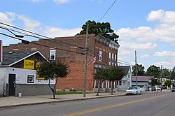
Main Street downtown
|
|
 Location of Marengo, Ohio |
|
 Location of Marengo in Morrow County |
|
| Coordinates: 40°24′5″N 82°48′37″W / 40.40139°N 82.81028°WCoordinates: 40°24′5″N 82°48′37″W / 40.40139°N 82.81028°W | |
| Country | United States |
| State | Ohio |
| County | Morrow |
| Area | |
| • Total | 0.17 sq mi (0.44 km2) |
| • Land | 0.17 sq mi (0.44 km2) |
| • Water | 0 sq mi (0 km2) |
| Elevation | 1,158 ft (353 m) |
| Population (2010) | |
| • Total | 342 |
| • Estimate (2012) | 344 |
| • Density | 2,011.8/sq mi (776.8/km2) |
| Time zone | Eastern (EST) (UTC-5) |
| • Summer (DST) | EDT (UTC-4) |
| ZIP code | 43334 |
| Area code(s) | 419 |
| FIPS code | 39-47558 |
| GNIS feature ID | 1042984 |
Marengo is a village in Morrow County, Ohio, United States. The population was 342 at the 2010 census. Marengo is south of Mount Gilead, the county seat.
Marengo was platted in 1873, although there had been permanent settlement at the site since the 1840s. A post office called Marengo was established in 1848.
Marengo is located at 40°24′5″N 82°48′37″W / 40.40139°N 82.81028°W (40.401341, -82.810382). It is considered to be a part of "Central Ohio".
According to the United States Census Bureau, the village has a total area of 0.17 square miles (0.44 km2), all of it land.
As of the census of 2010, there were 342 people, 133 households, and 92 families residing in the village. The population density was 2,011.8 inhabitants per square mile (776.8/km2). There were 148 housing units at an average density of 870.6 per square mile (336.1/km2). The racial makeup of the village was 95.3% White, 1.2% from other races, and 3.5% from two or more races. Hispanic or Latino of any race were 1.5% of the population.
...
Wikipedia
