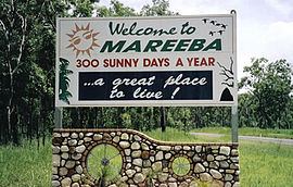
Mareeba, Queensland
|
Mareeba Queensland |
|||||||||||||
|---|---|---|---|---|---|---|---|---|---|---|---|---|---|
 |
|||||||||||||
| Coordinates | 16°59′0″S 145°25′0″E / 16.98333°S 145.41667°ECoordinates: 16°59′0″S 145°25′0″E / 16.98333°S 145.41667°E | ||||||||||||
| Population | 10,181 (2011 census) | ||||||||||||
| Established | 1877 | ||||||||||||
| Postcode(s) | 4880 | ||||||||||||
| Elevation | 400 m (1,312 ft) | ||||||||||||
| LGA(s) | Shire of Mareeba | ||||||||||||
| State electorate(s) | Cook | ||||||||||||
| Federal Division(s) | Kennedy | ||||||||||||
|
|||||||||||||
|
|||||||||||||
Mareeba /məˈriːbə/ is a town on the Atherton Tableland in Far North Queensland, Australia. The town is 417 metres (1,368 ft) above sea level on the confluence of the Barron River, Granite Creek and Emerald Creek. It is within the local government area of Shire of Mareeba (between 2008 and 2013, it was within the Tablelands Region). The town's name is derived from an Aboriginal word meaning meeting of the waters. In the 2011 census, Mareeba had a population of 10,181 people.
Prior to European settlement, the area around Mareeba was inhabited by the Muluridji people. They maintained a hunter/gatherer existence in the area between Mount Carbine, Mareeba, Rumula (near Julatten) and Woodville (near Canoona), mainly concentrated between Biboohra and Mount Molloy. In the local Aboriginal language, Mareeba means meeting of the waters - referring to the point at which the Barron River is joined by Granite Creek.
On 26 May 1875 James Venture Mulligan became the first European officially to see the future site of Mareeba when he rode up the eastern bank of the Barron River, and passed the junctions of Emerald Creek and Granite Creek.
...
Wikipedia

