Marajó várzea
| Marajó várzea | |
|---|---|

Marajó island
|
|

Islands in the estuary at the heart of the ecoregion
|
|
| Ecology | |
| Realm | Neotropical |
| Biome | Tropical and subtropical moist broadleaf forests – Amazon |
| Geography | |
| Area | 88,577.59 km2 (34,200.00 sq mi) |
| Country | Brazil |
| Coordinates | 0°26′38″N 50°19′23″W / 0.444°N 50.323°WCoordinates: 0°26′38″N 50°19′23″W / 0.444°N 50.323°W |
The Marajó várzea (NT0138) is an ecoregion of seasonally and tidally flooded várzea forest in the Amazon biome. It covers a region of sedimentary islands and floodplains at the mouth of the Amazon that is flooded twice daily as the ocean tides push the river waters onto the land. The flooded forests provide food for a wide variety of fruit-eating fish, aquatic mammals, birds and other fauna. It has no protected areas and is threatened by cattle and water-buffalo ranching, logging and fruit plantations.
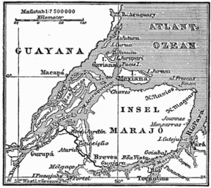
The Marajó várzea is at the mouth of the Amazon River. It covers coastal areas of the states of Pará and Amapá, with an area of 8,857,759 hectares (21,888,000 acres). Water levels are affected by freshwater flowing down the river and by tidal flows from the Atlantic Ocean. The várzea forest in the ecoregion starts where the Xingu River joins the Amazon, which begins to broaden out. It covers the west of Marajó Island and many smaller islands in the Amazon channel, as well as parts of the mainland to the north and south of the river mouth including a small area of French Guiana. The nutrient-rich sediments from the river are deposited on the islands.
The Marajó várzea ecoregion adjoins the and the to the south, and the Uatuma-Trombetas moist forests and an area of Guianan savanna to the north. The Gurupa várzea is upstream along the Amazon. There are strips of Amazon-Orinoco-Southern Caribbean mangroves along the coast. The Amapá mangroves are found to the north of the Amazon's mouth and the Pará mangroves to the south.
The Marajó várzea covers flooded land at the mouth of the 6,500 kilometres (4,000 mi) Amazon River. There are many islands including the 48,000 square kilometres (19,000 sq mi) Marajó island and the smaller Porcos, Pará, Mututí and Uituquara islands. The estuary is a recent lowland that has been forming during the present Holocene epoch, and is surrounded by Tertiary deposits. The constant action of tides and river flow form a maze of channels. Twice daily the tides push river discharge onto the low-lying land to a depth of 2 to 3 metres (6 ft 7 in to 9 ft 10 in). Soils in the many islands formed from the Amazon sediments are typically mottled clay with poor drainage.
...
Wikipedia
