Maplewood, New Jersey
| Maplewood, New Jersey | |
|---|---|
| Township | |
| Township of Maplewood | |

Municipal Building
|
|
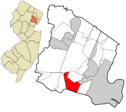
 Location in Essex County and the state of New Jersey. |
|
 Census Bureau map of Maplewood, New Jersey |
|
| Coordinates: 40°43′58″N 74°16′16″W / 40.732672°N 74.271125°WCoordinates: 40°43′58″N 74°16′16″W / 40.732672°N 74.271125°W | |
| Country |
|
| State |
|
| County | Essex |
| Incorporated | April 1, 1861 as South Orange Township |
| Renamed | November 7, 1922 as Maplewood township |
| Government | |
| • Type | Township |
| • Body | Township Committee |
| • Mayor | Victor DeLuca (D, term ends December 31, 2016) |
| • Administrator | Joseph F. Manning |
| • Clerk | Elizabeth J. Fritzen |
| Area | |
| • Total | 3.879 sq mi (10.048 km2) |
| • Land | 3.877 sq mi (10.043 km2) |
| • Water | 0.002 sq mi (0.006 km2) 0.06% |
| Area rank | 302nd of 566 in state 11th of 22 in county |
| Elevation | 115 ft (35 m) |
| Population (2010 Census) | |
| • Total | 23,867 |
| • Estimate (2015) | 24,700 |
| • Rank | 103rd of 566 in state 11th of 22 in county |
| • Density | 6,155.3/sq mi (2,376.6/km2) |
| • Density rank | 82nd of 566 in state 9th of 22 in county |
| Time zone | Eastern (EST) (UTC−5) |
| • Summer (DST) | Eastern (EDT) (UTC−4) |
| ZIP code | 07040 |
| Area code(s) | 973 |
| FIPS code | 3401343800 |
| GNIS feature ID | 0882220 |
| Website | www |
Maplewood is a suburban township in Essex County, New Jersey, United States. As of the 2010 United States Census, the township's population was 23,867, reflecting a decline of 1 person (0.0%) from the 23,868 counted in the 2000 Census, which had in turn increased by 2,216 (+10.2%) from the 21,652 counted in the 1990 Census.
When surveying the area now known as Maplewood, Robert Treat found several trails used by Lenape tribes of Algonquian Native Americans, though there was only sparse pre-European settlement. These paths form the basis for what are the town's main thoroughfares today.
The first European settlers arrived around 1675, primarily English, Dutch and French Puritans who had earlier settled Hempstead, Long Island, and Stamford, Connecticut, via Newark and Elizabeth. They had acquired most of today's Essex County from the Native Americans and followed three trails that roughly correspond to South Orange Avenue, Springfield Avenue, and Ridgewood Road. These three routes resulted in the development of three separate communities that coalesced to become Maplewood and South Orange.
Those who came from Newark on the trail that now corresponds to South Orange Avenue settled the area that became South Orange village.
Six families (with last names of Smith, Brown, Pierson, Freeman, Ball and Gildersleeve) came up today's Ridgewood Road and established scattered farms around a center that became Jefferson Village, named after Thomas Jefferson. This village, which roughly corresponds to downtown Maplewood today, developed several mills and orchards. John Durand, the son of Hudson River school painter Asher Brown Durand (who was born in Maplewood in 1796), describes the place as a picturesque but slightly backwards community with close ties to Springfield. The apple harvest was apparently quite impressive and included "Harrison" and "Canfield" varieties. By 1815, there were approximately 30 families in the village. Although the residents of the area were predominantly Presbyterian, the first house of worship was a Baptist chapel in 1812. This was in use until 1846 and fell into disrepair until 1858, when it was taken into use as a Methodist Episcopal church.
...
Wikipedia
