Maple Park, Illinois
| Maple Park | |
| Village | |
| Country | United States |
|---|---|
| State | Illinois |
| County | DeKalb, Kane |
| Coordinates | 41°54′31″N 88°35′53″W / 41.90861°N 88.59806°WCoordinates: 41°54′31″N 88°35′53″W / 41.90861°N 88.59806°W |
| Area | 2.36 sq mi (6 km2) |
| - land | 2.35 sq mi (6 km2) |
| - water | 0.00 sq mi (0 km2) |
| Population | 1,310 (2010) |
| Density | 555.1/sq mi (214/km2) |
| Village President | Kathy Curtis |
| Timezone | CST (UTC-6) |
| - summer (DST) | CDT (UTC-5) |
| Postal code | 60151 |
| Area code | 815 |
|
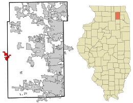
Location in Kane County and the state of Illinois.
|
|
| Website: www.villageofmaplepark.com | |
Maple Park is a village in DeKalb and Kane counties in the U.S. state of Illinois. The population was 1,310 at the 2010 census, up from 765 in 2000. Maple Park was formerly known as Lodi.
Maple Park was originally called Lodi, after Lodi, Lombardy. The present name comes from a nearby grove of sugar maple trees. A post office called Lodi was established first in 1837, and the post office was renamed Maple Park in 1880.
Maple Park is located at 41°54′31″N 88°35′53″W / 41.90861°N 88.59806°W (41.908514, -88.597989), primarily within Kane County.
According to the 2010 census, Maple Park has a total area of 2.353 square miles (6.09 km2), of which 2.35 square miles (6.09 km2) (or 99.87%) is land and 0.003 square miles (0.01 km2) (or 0.13%) is water.
As of the census of 2000, there were 765 people, 280 households, and 208 families residing in the village. The population density was 1,288.1 people per square mile (500.6/km²). There were 289 housing units at an average density of 486.6 per square mile (189.1/km²). The racial makeup of the village was 97.52% White, 0.39% Native American, 0.13% Asian, 0.92% from other races, and 1.05% from two or more races. Hispanic or Latino of any race were 2.48% of the population.
...
Wikipedia

