Many, Louisiana
| Many, Louisiana | |
| Town | |
|
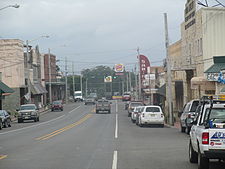
Downtown Many facing west
|
|
| Country | United States |
|---|---|
| State | Louisiana |
| Parish | Sabine |
| Elevation | 276 ft (84.1 m) |
| Coordinates | 31°37′04″N 93°28′40″W / 31.61778°N 93.47778°WCoordinates: 31°37′04″N 93°28′40″W / 31.61778°N 93.47778°W |
| Area | 3.1 sq mi (8.0 km2) |
| - land | 3.1 sq mi (8 km2) |
| - water | 0.0 sq mi (0 km2), 0% |
| Population | 2,706 (2010) |
| Density | 923.4/sq mi (356.5/km2) |
| Government | Kenneth Freeman |
| Timezone | CST (UTC-6) |
| - summer (DST) | CDT (UTC-5) |
| Area code | 318 |
|
Location of Louisiana in the United States
|
|
Many is a town in and the parish seat of Sabine Parish in western Louisiana, United States. The population was 2,706 at the 2010 census, a decrease of 183 or 6 percent from 2000.
The community has the name of one Colonel Many, an officer stationed at nearby Fort Jesup.
Many is located at 31°34′4″N 93°28′40″W / 31.56778°N 93.47778°W (31.567769, -93.477721). According to the United States Census Bureau, the town has a total area of 3.1 square miles (8.0 km2), all of it land.
Climate is characterized by relatively high temperatures and evenly distributed precipitation throughout the year. According to the Köppen Climate Classification system, Many has a humid subtropical climate, abbreviated "Cfa" on climate maps.
923.4 people per square mile (356.4/km²). There were 1,272 housing units at an average density of 406.5 per square mile (156.9/km²). The racial makeup of the town was 48.18% White, 47.42% African American, 1.70% Native American, 0.48% Asian, 0.03% Pacific Islander, 0.28% from other races, and 1.90% from two or more races. Hispanic or Latino of any race were 1.70% of the population.
...
Wikipedia


