Manoel Island
| Native name: Il-Gżira Manoel | |
|---|---|

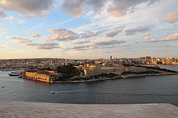
Manoel Island as seen from Valletta
|
|
| Map of Manoel Island within Marsamxett Harbour | |
| Geography | |
| Location | Marsamxett Harbour, Malta, south of Sicily, Mediterranean Sea |
| Coordinates | 35°54′14″N 14°30′07″E / 35.904°N 14.502°E |
| Archipelago | Maltese islands |
| Area | 0.3 km2 (0.12 sq mi) |
| Administration | |
|
Malta
|
|
Manoel Island (Maltese: Il-Gżira Manoel) is a small island which forms part of the municipality of Gżira in Marsamxett Harbour, Malta. It is named after the Portuguese Grand Master António Manoel de Vilhena, who built a fort on the island in the 1720s. Previously, the island had been known as l'Isolotto or l'Isola del Vescovo (Maltese: Il-Gżira tal-Isqof).
Manoel Island is a flat island shaped roughly like a leaf. It is located in the middle of Marsamxett Harbour, with Lazzaretto Creek to its south and Sliema Creek to its north. The island is connected to mainland Malta by a bridge. The whole island can be viewed from the bastions of the capital Valletta.
In 1570, the island was acquired by the Cathedral Chapter of Mdina and it became the property of the Bishop of Malta. It was therefore called l'Isola del Vescovo or il-Gżira tal-Isqof in Maltese (the Bishop's Island).
In 1592, a quarantine hospital known as Lazzaretto was built after an outbreak of the plague. The hospital was made of wooden huts, and it was pulled down a year later after the disease had subsided. In 1643, during the reign of Grandmaster Lascaris, the Order of Saint John exchanged the island with the church for some land in Rabat and built a permanent Lazzaretto in an attempt to control the periodic influx of plague and cholera on board visiting ships. It was initially used as a quarantine centre where passengers from quarantined ships were taken. The hospital was subsequently improved during the reigns of Grandmasters Cotoner, Carafa and de Vilhena.
...
Wikipedia

