Manimala River
| Manimala River | |
|---|---|

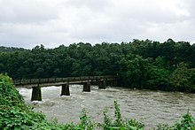
Manimala river near Cheruvally
|
|
| Native name | മണിമലയാർ |
| Other name(s) | Pullukayar, Vallapuzha |
| Country | India |
| State | Kerala |
| Districts | Kottayam, Pathanamthitta, Alappuzha |
| Cities | Mundakayam, Manimala, Kanjirappally, Mallappally, Kaviyoor, Kallooppara, Thalavadi, Champakulam, Kozhimukku |
| Basin features | |
| Main source | Muthavara hills, Western ghats 2,500 ft (760 m) |
| River mouth | Joins Pamba River at Muttar |
| Basin size | 802.90 km2 (310.00 sq mi) |
| Landmarks | Kallooppara Bhagavathy temple, Kaviyoor Mahadevar Temple, |
| Physical characteristics | |
| Length | 91.73 km (57.00 mi) |
Manimala River is a 92 km long river in South and Central Kerala. Though the river is a tributary of Pamba River, it is considered a separate river for geographical purposes. It has its origin on the Muthavara Hills (2500 feet above main sea level) on the Western Ghats, in Idukki district of Kerala, India. The river passes through the districts of Kottayam, Pathanamthitta and finally joins the Pamba River at Muttar near Tiruvalla in Alappuzha district.Yendayaar, Koottikkal, Mundakayam, Erumeli, Manimala, Kottangal, Kulathurmoozy, Vaipur, Mallappally, Thuruthicad, Vennikkulam, Kaviyoor, Kallooppara, Niranam, Muttar, Thalavadi, Kozhimukku, pulincunnoo, moncompu and Champakkulam lie on the banks of Manimala River. Its running length is estimated at 92 km. It empties itself into the Vembanad Lake.
Niranam was an ancient sea port at the confluence of Manimala River and Pamba River. At Kaviyoor ancient rock-cut cave temples can still be seen.
Manimala River has been an important water way of Central Travancore. Rising in the hills of Kottayam-Idukki ranges, running westward, the river joins the plains at Manimala junction and then the flows through the midland plains and through the Kuttanad rice bowl area. Sand mining on the river bed has led to depletion of the water ways of the river.
...
Wikipedia
