Mangonia Park, Florida
| Mangonia Park, Florida | |
|---|---|
| Town | |
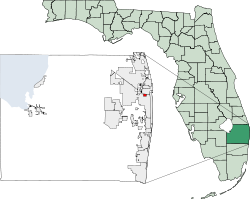
 Location of Mangonia Park in Palm Beach County, Florida |
|
| Coordinates: 26°45′29″N 80°4′26″W / 26.75806°N 80.07389°WCoordinates: 26°45′29″N 80°4′26″W / 26.75806°N 80.07389°W | |
| Country |
|
| State |
|
| County | Palm Beach |
| Area | |
| • Total | 0.7 sq mi (1.8 km2) |
| • Land | 0.7 sq mi (1.8 km2) |
| • Water | 0.0 sq mi (0.0 km2) |
| Elevation | 16 ft (5 m) |
| Population (2000) | |
| • Total | 1,283 |
| • Density | 1,809.7/sq mi (698.7/km2) |
| Time zone | Eastern (EST) (UTC-5) |
| • Summer (DST) | EDT (UTC-4) |
| ZIP code | 33407 |
| Area code(s) | 561 |
| FIPS code | 12-42900 |
| GNIS feature ID | 0286375 |
Mangonia Park is a town in Palm Beach County, Florida, United States. It is a part of Uptown West Palm, which also includes Riviera Beach and West Palm Beach. The population was 1,283 at the 2000 census. As of 2004, the population recorded by the U.S. Census Bureau was 1,289.
The Town of Mangonia Park was established in 1947. The original petition, to the State of Florida, requested the name Town of Magnolia Park. The petition for incorporation was granted but under the name Town of Mangonia Park. An explanation accompanied the charter stating the name, Town of Magnolia Park, was already taken and the State of Florida took the liberty of naming the town with a similar name.
It has a Town Manager-Town Council type of local government, with council members elected to five "at-large" seats that serve three year staggered terms. Municipal elections are held in March of each year by the Palm Beach County Supervisor of Elections Office.
Mangonia Park is located at 26°45′29″N 80°04′26″W / 26.758122°N 80.073877°W.
According to the United States Census Bureau, the town has a total area of 0.7 square miles (1.8 km2), all land.
As of the census of 2000, there were 1,283 people, 443 households, and 322 families residing in the town. The population density was 1,809.7 inhabitants per square mile (697.7/km²). There were 490 housing units at an average density of 691.2 per square mile (266.5/km²). The racial makeup of the town was 14.58% White (of which 12.2% were Non-Hispanic White,) 76.70% African American, 0.70% Native American, 0.31% Asian, 6.16% from other races, and 1.56% from two or more races. Hispanic or Latino of any race were 9.12% of the population.
...
Wikipedia
