Mangatarem
| Mangatarem | ||
|---|---|---|
| Municipality | ||
 |
||
|
||
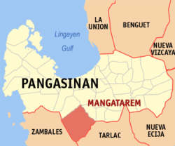
 Map of Pangasinan showing the location of Mangatarem |
||
| Location within the Philippines | ||
| Coordinates: 15°47′N 120°18′E / 15.783°N 120.300°ECoordinates: 15°47′N 120°18′E / 15.783°N 120.300°E | ||
| Country |
|
|
| Region | Ilocos (Region I) | |
| Province | Pangasinan | |
| District | 2nd district of Pangasinan | |
| Founded | 1837 | |
| Barangays | 82 | |
| Government | ||
| • Mayor | Balong Ventenilla | |
| • Vice Mayor | Teodoro C. Cruz | |
| • Electorate | 44,564 voters (2016 election) | |
| Area | ||
| • Total | 317.50 km2 (122.59 sq mi) | |
| Population (2015 census) | ||
| • Total | 73,241 | |
| • Density | 230/km2 (600/sq mi) | |
| Time zone | PST (UTC+8) | |
| ZIP code | 2413 | |
| 015527000 | ||
| IDD : area code | +63 (0)75 | |
| Income class | 1st municipal income class | |
| Revenue | ₱ 23,540,761.00 (2016) | |
| Poverty incidence | 10.62 (2012) | |
Mangatarem (Pangasinan: Baley na Mangatarem; Ilocano: Ili ti Mangatarem) is a 1st class municipality in the province of Pangasinan, Philippines. According to the 2015 census, it has a population of 73,241 people.
Mangatarem is a Pangasinan word for "mango plantation" The town's name also came from the Ilocano Phrase which means "mango and oyster".
The municipality is home to the Manleluag Spring Protected Landscape.
Mangatarem is politically subdivided into 82 barangays.
...
Wikipedia


