Mangaldai
|
Mangaldai মঙলদৈ |
|
|---|---|
| Town | |

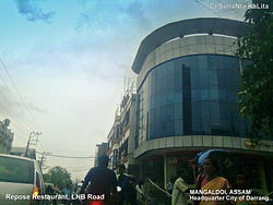
View of Mangaldoi Repose building in LNB Road
|
|
| Location in Assam, India | |
| Coordinates: 26°26′N 92°02′E / 26.43°N 92.03°ECoordinates: 26°26′N 92°02′E / 26.43°N 92.03°E | |
| Country |
|
| State | Assam |
| District | Darrang |
| Founded by | Government of Assam |
| Government | |
| • Body | Mangaldoi Municipality Board |
| Elevation | 34 m (112 ft) |
| Population (2011) | |
| • Total | 25,989 |
| Languages | |
| • Official | Assamese |
| Time zone | IST (UTC+5:30) |
| PIN | 784125 |
| Vehicle registration | AS-13 * **** |
| Sex ratio | 923:1000 ♂/♀ |
| Website | darrang |
Mangaldai (Assamese: মঙ্গলদৈ, /ˈmæŋɡəlˌdɔɪ/; also spelt Mangaldoi) is a small town in the Indian state of Assam. It was named after Mangaldahi, who was the daughter of the Rajah of Darrang and was married to Pratap Singha, a ruler of the Ahom kingdom. Mangaldoi serves as the administrative headquarters of Darrang district, and is an important trading centre for agricultural products. The town is divided into 9 wards.
Mangaldoi is located at 26°26′N 92°02′E / 26.43°N 92.03°E. It has an average elevation of 34 m (112 ft).
Situated at the north bank of Brahmaputra river, the town is 65 km from Guwahati. Its total area is 5 km2.
Town & Villages nearby include Kharupetia (only Town Committee in Darrang District) Upahupara, Dighirpar, Aulachowka, Saikiapara, Lengeripara, Chapai, Menapara, Dhula, Patharughat, Balipota, Sipajhar, Maroi, Duminichowki, Sanowa, Deomornoi, Kalaigaon, Balugaon and Dalgaon, Lengeriajhar, Jonaram Chowka, Dipila, Duni, Bonmajha - Hengalpara etc.
Mangaldai Town Girls'Higher Secondary School SEBA
As of 2011[update] India census, Mangaldoi had a population of 42,946. Males constitute 52% of the population and females 48%. Mangaldoi has an average literacy rate of 81%, higher than the national average of 59.5%: male literacy is 85%, and female literacy is 76%. In Mangaldoi, 11% of the population is under 6 years of age.
...
Wikipedia


