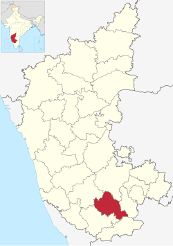
Mandya District
|
Mandya district ಮಂಡ್ಯ ಜಿಲ್ಲೆ |
|
|---|---|
| district | |

|
|
| Nickname(s): Sakkare Nadu | |
 Location in Karnataka, India |
|
| Coordinates: 12°31′N 76°54′E / 12.52°N 76.9°ECoordinates: 12°31′N 76°54′E / 12.52°N 76.9°E | |
| Country |
|
| State | Karnataka |
| Region | Bayaluseeme |
| Division | Mysore Division |
| Established | 1 July 1939 |
| Headquarters | Mandya |
| Talukas | Mandya, Malavalli, Maddur, Nagamangala, Krishnarajpet, Pandavapura, Srirangapatna |
| Government | |
| • Deputy Commissioner | ZIYAULLAH S IAS |
| Area | |
| • Total | 4,961 km2 (1,915 sq mi) |
| Population (2011) | |
| • Total | 1,805,769 |
| • Density | 360/km2 (940/sq mi) |
| Languages | |
| • Official | Kannada |
| Time zone | IST (UTC+5:30) |
| ISO 3166 code | IN-KA-MA |
| Vehicle registration | KA-11,(KA-54 nagamangala) |
| Sex ratio | 1.015 ♂/♀ |
| Literacy | 70.40 % |
| Lok Sabha constituency | Mandya Lok Sabha constituency |
| Climate | Tropical Semi-arid (Köppen) |
| Precipitation | 691 millimetres (27.2 in) |
| Avg. summer temperature | 35 °C (95 °F) |
| Avg. winter temperature | 16 °C (61 °F) |
| Website | mandya |
Mandya District is an administrative district of Karnataka, India. Mandya District borders on the south by Mysore District, on the west by Hassan District, on the north by Tumkur District and on the east by Ramanagar district. The district was formed in the year 1939.Mandya district is called as "SAKKARE NADU"(ಸಕ್ಕರೆ ನಾಡು ಮಂಡ್ಯ)because of Sugarcane is Major crop grown here,and people's of here are most lovely and kindness so they are called as"SAKKARE NADINA AKKARE JANATHE" (ಸಕ್ಕರೆ ನಾಡಿನ ಅಕ್ಕರೆ ಜನತೆ).
The main town is in Mandya District is Mandya. As of 2011, the district population was 1,808,680 of which 16.03% was urban.
Mandya district gets its name from the city of Mandya which is also the headquarters of the district. Although the widely purported mythical story about the name is that the region is named after a sage called Maandavya, but scholars and academicians have stated based on ancient inscription that this region was referred as 'Man-ta-ya' (ಮಂಟಯ), meaning a habitat preceding a civilization or roughly an ancient abode ("ಆವಾಸಸ್ತಾನ, ಅತ್ಯಂತ ಪ್ರಾಚೀನವಾದ ನಾಗರೀಕತೆಗೂ ಮುನ್ನಿನ ಜನವಸತಿ ಎಂಬ ಅರ್ಥವಿದೆ". "ಸುವರ್ಣ ಮಂಡ್ಯ" ಪುಸ್ತಕದಿಂದ - ಸಂಪಾದಕರು ದೇ. ಜವಾರೇಗೌಡ (ದೇಜಗೌ)). And gradually it became Mandya.
Mandya's history is closely related to the history of the old Mysore State, which included the present district of Mandya and areas around the Cauvery Basin. Ruled successively by the kings of the Ganga dynasty and then the Cholas and the Hoysalas, the area was annexed by the rulers of Vijayanagara in 1346. After the cruel battle of 1565 When the Vijayanagara king was defeated by the combined power of the Sultans of the Deccan, the Vijayanagara Empire began to lose its power and extent. The Wodeyars of Mysore gradually grew in importance. Before long, they had established their own rule over a large part of South India which included all of old Mysore, parts of the present Tamil Nadu and the districts of Dakshina Kannada and Dharwar, with Srirangapatna as their capital.
...
Wikipedia
