Manchester, Pennsylvania
| Manchester, Pennsylvania | |
|---|---|
| Borough | |

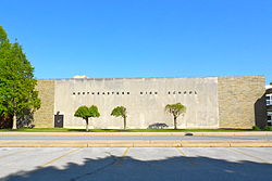
Northeastern High School
|
|
 Location in York County and the state of Pennsylvania. |
|
| Coordinates: 40°03′39″N 76°43′11″W / 40.06083°N 76.71972°WCoordinates: 40°03′39″N 76°43′11″W / 40.06083°N 76.71972°W | |
| Country | United States |
| State | Pennsylvania |
| County | York |
| Settled | 1814 |
| Incorporated | 1869 |
| Government | |
| • Type | Borough Council |
| • Mayor | Martin Keister |
| Area | |
| • Total | 0.79 sq mi (2.03 km2) |
| • Land | 0.79 sq mi (2.03 km2) |
| • Water | 0.00 sq mi (0.00 km2) |
| Elevation | 453 ft (138 m) |
| Population (2010) | |
| • Total | 2,763 |
| • Estimate (2016) | 2,746 |
| • Density | 3,498.09/sq mi (1,349.89/km2) |
| Time zone | Eastern (EST) (UTC-5) |
| • Summer (DST) | EDT (UTC-4) |
| Zip code | 17345 |
| Area code(s) | 717 |
| FIPS code | 42-46864 |
| Website | manchesterborough.com |
Manchester is a borough in York County, Pennsylvania, United States. The population was 2,763 at the 2010 census.
Settled in 1814, the village of Liverpool (now Manchester) was incorporated in 1869 in the eastern section of Manchester Township. During the Gettysburg Campaign of the American Civil War, Liverpool's merchants were raided by the 17th Virginia Cavalry.
Manchester is located at 40°03′39″N 76°43′11″W / 40.060943°N 76.719626°W.
According to the United States Census Bureau, the borough has a total area of 0.8 square miles (2.1 km2), all of it land.
As of the census of 2000, there were 2,350 people, 1,009 households, and 664 families residing in the borough. The population density was 2,986.4 people per square mile (1,148.5/km2). There were 1,058 housing units at an average density of 1,344.5 per square mile (517.1/km2). The racial makeup of the borough was 97.28% White, 0.47% African American, 0.26% Native American, 0.26% Asian, 0.89% from other races, and 0.85% from two or more races. Hispanic or Latino of any race were 1.49% of the population.
...
Wikipedia
