Manchester, Bolton and Bury Canal
| Manchester Bolton & Bury Canal | |
|---|---|

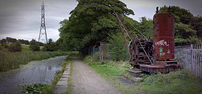
The Grade II Listed steam crane at Mount Sion, on the Bury arm
|
|
| Specifications | |
| Maximum boat length | 68 ft 0 in (20.73 m) |
| Maximum boat beam | 14 ft 2 in (4.32 m) (originally 7 ft 0 in or 2.13 m) (Widened from 1794) |
| Locks | 16 (originally 12 and later 17) (5 added for Irwell extension making 17 total, as of 2008 a single deep lock has replaced locks 1&2) |
| Maximum height above sea level | 247 ft (75 m) |
| Status | Under restoration |
| Navigation authority | Canal and River Trust |
| History | |
| Original owner | Manchester Bolton & Bury Canal Company |
| Principal engineer | Matthew Fletcher |
| Other engineer(s) | Hugh Henshall, Charles Roberts, John Nightingale |
| Date of act | 1791 |
| Date of first use | 1797 |
| Date completed | 1808 |
| Date closed | 1924, 1941, 1961 |
| Geography | |
| Start point |
River Irwell, Salford (originally Oldfield Road, Salford) |
| End point | Bury and Bolton |
| Branch(es) | Fletcher's Canal |
| Manchester Bolton & Bury Canal | |||||||||||||||||||||||||||||||||||||||||||||||||||||||||||||||||||||||||||||||||||||||||||||||||||||||||||||||||||||||||||||||||||||||||||||||||||||||||||||||||||||||||||||||||||||||||||||||||||||||||||||||||||||||||||||||||||
|---|---|---|---|---|---|---|---|---|---|---|---|---|---|---|---|---|---|---|---|---|---|---|---|---|---|---|---|---|---|---|---|---|---|---|---|---|---|---|---|---|---|---|---|---|---|---|---|---|---|---|---|---|---|---|---|---|---|---|---|---|---|---|---|---|---|---|---|---|---|---|---|---|---|---|---|---|---|---|---|---|---|---|---|---|---|---|---|---|---|---|---|---|---|---|---|---|---|---|---|---|---|---|---|---|---|---|---|---|---|---|---|---|---|---|---|---|---|---|---|---|---|---|---|---|---|---|---|---|---|---|---|---|---|---|---|---|---|---|---|---|---|---|---|---|---|---|---|---|---|---|---|---|---|---|---|---|---|---|---|---|---|---|---|---|---|---|---|---|---|---|---|---|---|---|---|---|---|---|---|---|---|---|---|---|---|---|---|---|---|---|---|---|---|---|---|---|---|---|---|---|---|---|---|---|---|---|---|---|---|---|---|---|---|---|---|---|---|---|---|---|---|---|---|---|---|---|---|
| |||||||||||||||||||||||||||||||||||||||||||||||||||||||||||||||||||||||||||||||||||||||||||||||||||||||||||||||||||||||||||||||||||||||||||||||||||||||||||||||||||||||||||||||||||||||||||||||||||||||||||||||||||||||||||||||||||
