Manaure, La Guajira
| Manaure | |||
|---|---|---|---|
| town | |||

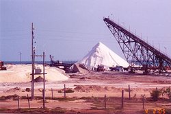
Salt mines in Manaure, La Guajira
|
|||
|
|||
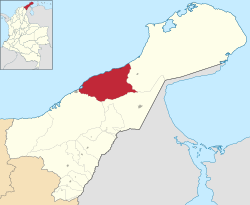
 Location of the town and municipality of Manaure in the Department of La Guajira. |
|||
| Location of the town and municipality of Manaure in the Department of La Guajira. | |||
| Coordinates: 11°46′45″N 72°26′58″W / 11.77917°N 72.44944°W | |||
| Country |
|
||
| Region | Caribbean | ||
| Department | La Guajira | ||
| Founded | 1723 | ||
| Government | |||
| • Mayor | Humberto Martinez Fajardo (C) | ||
| Area | |||
| • Total | 1,971 km2 (761 sq mi) | ||
| Elevation | 3 m (10 ft) | ||
| Population (2005) | |||
| • Total | 68,578 | ||
| • Density | 35/km2 (90/sq mi) | ||
| Demonym(s) | Manaurero | ||
| Area code(s) | 57 + 5 | ||
| Climate | BSh | ||
| Website | Official website (in Spanish) | ||
| * | |||
Manaure or Salinas de Manaure is a town and municipality located in the Colombian Department of La Guajira. Manaure's main economic activity is the exploitation of the vast amounts of salt in the area.
The municipality of Manaure is located in northernmost part of South America, on the arid plains of the Guajira Peninsula, in the Colombian Caribbean region, bordering to the north with the Caribbean Sea to the east with the municipality of Uribia; to the south with the municipality of Maicao and to the west with the municipality of Riohacha.
The municipality of Manaure is within the Guajira-Barranquilla xeric scrub with water streams determined by precipitations during the rainy seasons. The municipality seat of Manaure is crossed by the Limón Creek which flows into the Caribbean sea. The coastline has high concentration of salt, rocks and clay over predominantly flat plains, slightly undulated in some areas.
Climate in the municipality of Manaure is hot and dry throughout the year, averaging between 28 °C (82 °F) and 38 °C (100 °F) throughout the year with constant winds from the northeastern trade winds, evaporation of humidity is high. The area has two rainy seasons averaging 150 mm from May to June and from October to November) and two dry seasons in between these months.
Chronicles from the Spanish explorer first detailed some indigenous in the area called Coanaos which traveled between the Cabo de la Vela and the region of Valledupar to exchange salt for gold. During the 19th century salt in the region was exploited at Honda Bay and Quebrada Bay on coasts of what is part of the municipality of Manaure which naturally formed lagoons. In 1777 the Spanish government ordered the administration of the Salinas.
In 1824 the government declared the Salinas or salt mines as national patrimony of the nation establishing a regulatory price control. In 1932 the bank of the Republic was given authority over the administration and exploitation of salt mines in Zipaquirá, Nemocón and Sesquilé.
...
Wikipedia


