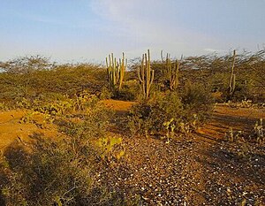
Guajira-Barranquilla xeric scrub
| Guajira-Barranquilla xeric scrub | |
|---|---|
 |
|
| Ecology | |
| Biome | Deserts and xeric shrublands |
| Geography | |
| Area | 150,000 km2 (58,000 sq mi) |
| Country | Colombia, Venezuela |
Coordinates: 11°N 74°W / 11°N 74°W
The Guajira-Barranquilla xeric scrub is a xeric shrubland ecoregion in Colombia and Venezuela, covering an estimated area of 150,000 km2 (58,000 sq mi). Rainfall varies from 125 to 1,000 mm (4.9 to 39.4 in), and the median temperature is 26 °C (79 °F).
The ecoregion occupies the Guajira Peninsula, the valley of Rancheria river and Guajira Department, covering parts of the northeastern coast of Venezuela. The valleys lie in the rain shadow of the surrounding Serranía de Macuira, which reaches an elevation of 900 m (3,000 ft) over sea level. These mountains trap some of the trade winds, causing mist. An important tourist destination in the area is Cabo de la Vela.
The ecoregion is dominated by thorny trees and succulents. Common species include Acacia glomerosa, Bourreria cumanensis, Bulnesia arborea, Caesalpinia coriaria, Copaifera venezolana, Croton sp., Gyrocarpus americanus, Hyptis sp., Jacquinia pungens, Malpighia glabra, Myrospermum frutescens, Opuntia caribaea, Pereskia guamacho, Piptadenia flava, Prosopis juliflora, and Stenocereus griseus.
...
Wikipedia
