Manassas Park
| Manassas Park, Virginia | ||
|---|---|---|
| Independent city | ||
| City of Manassas Park | ||

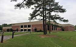
Manassas Park community center
|
||
|
||
| Coordinates: 38°46′24″N 77°27′12″W / 38.77333°N 77.45333°W | ||
| Country | United States | |
| State | Virginia | |
| County | None (Independent city) | |
| Incorporated | 1975 | |
| Government | ||
| • Mayor | Jeanette Rishell | |
| Area | ||
| • Total | 2.5 sq mi (6 km2) | |
| • Land | 2.5 sq mi (6 km2) | |
| • Water | 0.0 sq mi (0 km2) | |
| Population (2010) | ||
| • Total | 14,273 | |
| • Density | 5,642/sq mi (2,178/km2) | |
| Zip Code | 20111 | |
| FIPS code | 51-48968 | |
| GNIS feature ID | 1495894 | |
| Website | City of Manassas Park | |
Manassas Park is an independent city in the U.S. state of Virginia. As of the 2010 census, the population was 14,273. Manassas Park is bordered by the city of Manassas and Prince William County. Manassas Park is a part of the Washington-Arlington-Alexandria, DC-VA-MD-WV Metropolitan Statistical Area. "A" Fort and Battery Hill Redoubt-Camp Early resides in Manassas Park.
Manassas Park was incorporated as a town in 1957 and incorporated as a city in 1975.
Manassas Park is located at 38°46′24″N 77°27′12″W / 38.77333°N 77.45333°W (38.773564, -77.453542).
According to the United States Census Bureau, the city has a total area of 2.5 square miles (6.5 km2), all of it land.
As of the census of 2000, there were 10,290 people, 3,254 households and 2,557 families residing in the city. The population density was 4,129.0 people per square mile (1,595.6/km²). There were 3,365 housing units at an average density of 1,350.3 per square mile (521.8/km²). The racial makeup of the city was 72.79% White, 11.17% African American, 0.44% Native American, 4.06% Asian, 0.07% Pacific Islander, 8.14% from other races, and 3.33% from two or more races. Hispanic or Latino of any race were 15.00% of the population.
...
Wikipedia


