Manapouri Hydroelectric Power Station
| Manapouri Power Station | |||||||||||||||||||
|---|---|---|---|---|---|---|---|---|---|---|---|---|---|---|---|---|---|---|---|

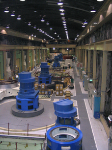
The Manapouri Power Station machine hall
|
|||||||||||||||||||
|
Location of Manapouri Power Station in New Zealand
|
|||||||||||||||||||
| Country | New Zealand | ||||||||||||||||||
| Location | west end of Lake Manapouri, Fiordland National Park, Southland | ||||||||||||||||||
| Coordinates | 45°31′17″S 167°16′40″E / 45.52139°S 167.27778°ECoordinates: 45°31′17″S 167°16′40″E / 45.52139°S 167.27778°E | ||||||||||||||||||
| Status | Operational | ||||||||||||||||||
| Construction began | February 1964 | ||||||||||||||||||
| Opening date | September 1971 | ||||||||||||||||||
| Construction cost |
NZ$135.5 million (original station) NZ$200 million (second tailrace tunnel) NZ$100 million (half-life refurbishment) |
||||||||||||||||||
| Owner(s) | Meridian Energy | ||||||||||||||||||
| Reservoir | |||||||||||||||||||
| Creates | Lake Manapouri | ||||||||||||||||||
| Catchment area | 3,302 km2 (1,275 sq mi) | ||||||||||||||||||
| Surface area | 141.6 km2 (54.7 sq mi) | ||||||||||||||||||
| Maximum water depth | 444 m (1,457 ft) | ||||||||||||||||||
| Power Station | |||||||||||||||||||
| Type | Conventional | ||||||||||||||||||
| Turbines | 7× vertical Francis
|
||||||||||||||||||
| Lake Manapouri is a natural lake - the drop between it and the sea is used by Manapouri station. ^c The former figure is based on the installed capacity of 850 MW, while the latter figure is based on the resource consent limited capacity of 800 MW |
|||||||||||||||||||
| Manapouri Power Station | |
|---|---|
 |
|
| Country | New Zealand |
| Coordinates | 45°31′17″S 167°16′41″E / 45.5214°S 167.278°ECoordinates: 45°31′17″S 167°16′41″E / 45.5214°S 167.278°E |
| Power generation | |
| Nameplate capacity | 850 MW |
| Capacity factor | 68.4% / 79.7% |
| Annual output | 5100 GWh |
Manapouri Power Station is an underground hydroelectric power station on the western arm of Lake Manapouri in Fiordland National Park, in the South Island of New Zealand. At 850 MW installed capacity (although limited to 800 MW due to resource consent limits), it is the largest hydroelectric power station in New Zealand, and the second largest power station in New Zealand. The station is noted for the controversy and environmental protests by the Save Manapouri Campaign against the raising the level of Lake Manapouri to increase the station's head, which galvanised New Zealanders and were one of the foundations of the New Zealand environmental movement.
Completed in 1971, Manapouri was built to supply electricity to the Tiwai Point aluminium smelter near Bluff, some 160 km (99 mi) to the southeast. Later, it was also connected into the South Island transmission network. The station utilises the 230-metre (750 ft) drop between the western arm of Lake Manapouri and the Deep Cove branch of the Doubtful Sound 10 km (6.2 mi) away to generate electricity. The construction of the station required the excavation of almost 1.4 million tonnes of hard rock to build the machine hall and a 10 km tailrace tunnel, with a second parallel tailrace tunnel completed in 2002 to increase the station's capacity.
Since April 1999, the power station has been owned and operated by state-owned electricity generator Meridian Energy.
The power station machine hall was excavated from solid granite rock 200 metres below the level of Lake Manapouri. Two tailrace tunnels take the water that passes through the power station to Deep Cove, a branch of Doubtful Sound, 10 kilometres (6.2 mi) away. Access to the power station is via a two-kilometre vehicle-access tunnel which spirals down from the surface, or a lift that drops 193 metres (633 ft) down from the control room above the lake. There is no road access into the site; a regular boat service ferries power station workers and tourists 35 km across the lake from Pearl Harbour, located in the town of Manapouri at the southeast corner of the lake.
...
Wikipedia


