Mamurogawa, Yamagata
|
Mamurogawa 真室川町 |
||
|---|---|---|
| Town | ||

Mamurogawa Town Hall
|
||
|
||
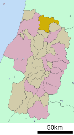
 Location of Mamurogawa in Yamagata Prefecture |
||
| Coordinates: 38°51′N 140°15′E / 38.850°N 140.250°ECoordinates: 38°51′N 140°15′E / 38.850°N 140.250°E | ||
| Country | Japan | |
| Region | Tōhoku | |
| Prefecture | Yamagata | |
| District | Mogami | |
| Area | ||
| • Total | 374.29 km2 (144.51 sq mi) | |
| Population (October 2013) | ||
| • Total | 8,607 | |
| • Density | 24/km2 (60/sq mi) | |
| Time zone | Japan Standard Time (UTC+9) | |
| - Tree | Prunus mume | |
| - Flower | Prunus mume | |
| Phone number | 0233-62-2111 | |
| Address | 127-7 Shincho, Mamurogawa-machi, Mogami-gun, Yamagata-ken 999-5301 | |
| Website | Official website | |
Mamurogawa (真室川町 Mamurogawa-machi?) is a town located in Mogami District, Yamagata Prefecture, Japan.
As of September 2013, the town has an estimated population of 8,607 and a population density of 23 persons per km². The total area was 374.29 square kilometres (145 sq mi).
Mamurogawa is located in the extreme northern Yamagata Prefecture, bordering on Akita Prefecture to the north. The town is located in the Shinjō Valley, surrounding by low mountains on all sides, with the Ou Mountains to the northeast. The area is known for its heavy snowfalls in winter.
The area of present-day Mamurogawa was part of ancient Dewa Province and the location of Sakenobe Castle in the Sengoku period. After the start of the Meiji period, the area became part of Mogami District, Yamagata Prefecture. The village of Mamurogawa was established on April 1, 1889. During World War II, an airbase for training pilots was established by the Imperial Japanese Army. The site is now a park, and part of the grounds of the local high school. Mamurogawa was elevated to town status on April 1, 1950. On August 1, 1954, it absorbed the neighboring villages of Araki and Nozoki.
The economy of Mamurogawa is based on agriculture and forestry.
...
Wikipedia


