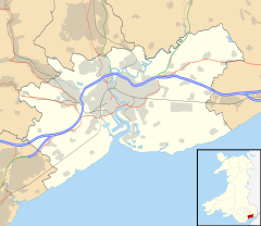
Malpas, Newport
| Malpas | |
|---|---|
| Malpas shown within Newport | |
| Population | 7,997 (2011) |
| OS grid reference | ST305908 |
| Principal area | |
| Country | Wales |
| Sovereign state | United Kingdom |
| Post town | NEWPORT |
| Postcode district | NP20 6 |
| Dialling code | 01633 Chartist exchange |
| Police | Gwent |
| Fire | South Wales |
| Ambulance | Welsh |
| EU Parliament | Wales |
| UK Parliament | |
Malpas is an electoral district (ward) and coterminous community (parish) of the city of Newport, South Wales. The area is governed by the Newport City Council.
The ward is bounded by the A4042 Heidenheim Drive to the east, the city boundary to the north, Malpas brook to the west, and Bettws Lane, Llanover Close, and the western and northern edges of Graig Wood, Yewberry Lane and Grove Park Drive to the south.
The name is French and comes from Mal (bad/poor) and Pas (passage/way). Earlier examples of the name include the definite article 'Le' and even an odd Welsh definite article 'Y' i.e. Le Malpas, Y Malpas.
There are two large housing estates either side of the main Malpas Road (A4051). To the west is Hollybush and the council estates Westfield and Malpas Court, although many of the houses are now in private ownership. To the east are the privately owned estates Woodlands, Malpas Park, Pilton Vale and Claremont. The roads in Malpas Court take their names from famous inventors and scientists, while those in Malpas Park are named after trees. The roads in Woodlands are named after World War II generals, e.g. Allenbrooke Avenue, Horrocks Close, Montgomery Road, Robertson Way, Wavell Drive, etc. Claremont and Pilton Vale however are just single street names with large house numbers.
The Malpas Institute Trust is a charitable fund, founded on the sale of the World War I Memorial Institute.
There are four primary schools in the ward. Malpas Church Infants, Malpas Church Juniors, Malpas Court, and Malpas Park.
...
Wikipedia

