Malargüe
| Malargüe | |
|---|---|
| City | |

Plaza San Martin
|
|
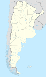
| Location of Malargüe in Argentina | |
| Coordinates: 35°28.5′S 69°35′W / 35.4750°S 69.583°WCoordinates: 35°28.5′S 69°35′W / 35.4750°S 69.583°W | |
| Country | Argentina |
| Province | Mendoza |
| Department | Malargüe |
| Elevation | 1,402 m (4,600 ft) |
| Population | |
| • Total | 23,020 |
| Time zone | ART (UTC-3) |
| CPA base | M5613 |
| Dialing code | +54 2627 |
| Climate | BSk |
Malargüe (Spanish pronunciation: [maˈlarɣwe]) is a city in the southwest part of province of Mendoza, Argentina, about 370 km south of the provincial capital Mendoza. It is the head town of the Malargüe Department, and it has about 23,000 inhabitants as per the 2001 census [INDEC].
The city is located in a semi-arid area. Agriculture is focused on the production of seed potato, along with minor crops such as alfalfa, onion and garlic. In the past, the local industries included oil exploration and production (now almost completely deactivated) and uranium mining. As a touristic area, Malargüe provides hotels and cabins for visitors interested in eco-tourism in the summer and skiing in the winter at the nearby resorts of Las Leñas and Los Molles.
The city is known for its traditional dish, the chivito (baby goat). It hosts the annual National Festival of the Goat and the Provincial Festival of the Lamb, during the second week of January.
Clock tower in the city center
Las Animas well
On 13 October 1972 the Uruguayan Air Force Flight 571 crashed in the Andes, in the municipal territory of Malargüe (34°45′54″S 70°17′11″W / 34.76500°S 70.28639°W).
...
Wikipedia

