Main Street Historic District (Medina, New York)
|
Main Street Historic District
|
|

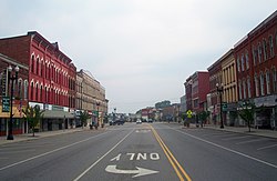
View north on Main Street from
Center Street junction, 2010. Fuller and J.A. French blocks on left. |
|
| Location | Medina, NY |
|---|---|
| Nearest city | Lockport |
| Coordinates | 43°13′13″N 78°23′13″W / 43.22028°N 78.38694°WCoordinates: 43°13′13″N 78°23′13″W / 43.22028°N 78.38694°W |
| Area | 12 acres (4.9 ha) |
| Built | 1845-1925 |
| Architectural style | Romanesque, Queen Anne, Italianate |
| NRHP reference # |
95000213 (original) 97001457 (increase) |
| Added to NRHP | March 23, 1995 (original) November 24, 1997 (increase) |
The Main Street Historic District in Medina, New York, United States, is the downtown commercial core of the village. It is a 12-acre (4.9 ha) area stretching south along Main Street from the Erie Canal to the railroad tracks.
Its buildings, all but three of which contribute to its historic character, reflect the development of Medina from the early days of the canal, where a bend in the route made it a natural harbor, in the 1830s to the 1920s. They are brick or stone buildings in a variety of architectural styles from the 19th century, primarily Italianate. Many of them have been renovated after a period of decline in the mid-20th century. In 1995 it was designated a historic district and listed on the National Register of Historic Places. Two years later, a rail freight depot at the south end was added when further research established that it was historically related to other buildings in the district.
The district is an irregularly shaped area whose axis is Main Street for a block and a half north and south of East and West Center Street (NY 31 and 31E/63 respectively. South of the Main-Center intersection, Main Street is also itself part of routes 31 and 63). Its boundaries are defined by lot lines and streets. The terrain is level with a slight descent to the canal and creek at the northeast.
At the north, the district includes the properties on the east side of Main north of Pearl Street that back on the canal just north of the bend it takes after crossing the Oak Orchard River to the immediate east. Its boundary continues along the rear property line of the east side of Main, excluding the parking lot at the canal basin, then expanding westward at East Center to include some properties on both sides of the street east of Manilla Place, stopping just short of St. John's Episcopal Church, the "Church in the Middle of the Street" and one of Medina's oldest public buildings. It then returns to the rear lines of the east side of Main, following the CSX railroad tracks back to the street.
...
Wikipedia


