Main North Road
|
Main North Road South Australia |
|
|---|---|
 |
|
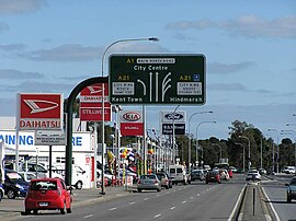
| Looking south at Main North Road's southern (city) end. According to signage, this section is not a part of the National Highway. | |
| Coordinates |
|
| Type | Road |
| Length | 307 km (191 mi) |
| Route number(s) |
|
| Former route number |
|
| North end |
|
|
|
| South end | Barton Terrace and O'Connell Street, North Adelaide |
| Major suburbs | Wilmington, Gladstone, Clare, Giles Corner, Gawler, Elizabeth |
Main North Road is the major north-south arterial route through the suburbs north of the Adelaide City Centre in the city of Adelaide, South Australia. It continues north through the settled areas of South Australia and is a total of 307 kilometres (191 mi) long, from North Adelaide to 21 kilometres (13 mi) out of Port Augusta. It follows the route established in the early years of the colony by explorer John Horrocks and was a major route for farmers and graziers to reach the capital, passing through rich farmland and the Clare Valley wine region. In 2011, the section of road between Gawler to Wilmington was renamed Horrocks Highway.
Main North Road from Gawler to Wilmington was renamed to the Horrocks Highway in 2011 to honour John Horrocks, an early explorer and pioneer in the region. However while Main North Road turns west in Wilmington through Horrocks Pass to join the Augusta Highway as route B56, route B82 carries the name Horrocks Highway north to Quorn.
Main North Road branches from the northern end of O'Connell Street (North Adelaide) and passes through the Adelaide Parklands and the suburbs of Thorngate, Medindie, Medindie Gardens, Nailsworth, Prospect, Sefton Park, Blair Athol and Enfield before reaching the major intersection at Gepps Cross. Here the road forks, with the Port Wakefield Road (A1 - National Highway 1) continuing to the north, and the Main North Road turning northeast and continuing as route A52.
...
Wikipedia

