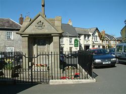
Magor, Monmouthshire
Magor
|
|
|---|---|
 War memorial in the centre of Magor |
|
| Magor shown within Monmouthshire | |
| Population | 6,140 (2011) |
| OS grid reference | ST425871 |
| Principal area | |
| Ceremonial county | |
| Country | Wales |
| Sovereign state | United Kingdom |
| Post town | CALDICOT |
| Postcode district | NP26 |
| Dialling code | 01633 |
| Police | Gwent |
| Fire | South Wales |
| Ambulance | Welsh |
| EU Parliament | Wales |
| UK Parliament | |
Magor (Welsh: Magwyr) - meaning 'a wall' - is a large village in Monmouthshire, south east Wales, between Chepstow and the city of Newport, and adjoining the Caldicot Levels beside the Severn Estuary. Magor lies close to the M4 motorway, and has a nearby motorway service area sharing its name. It is within the commuter belts of Newport, Bristol and Cardiff.
The original Welsh language name Magwyr, from which the English name is derived, is thought to originate from the Latin maceria, meaning masonry walls or ruins. It may relate either to a now-lost Roman villa in the area, or alternatively to sea defences or a causeway built by the Romans. Magor and the surrounding area contain many Roman ruins and artefacts, and the village centre was originally located at the inner edge of salt marshes which the Romans began to reclaim as farmland. The local name "Whitewall" may relate to the same causeway, which would have connected the village to a small now-vanished harbour on the Severn Estuary known as Abergwaitha or Aberweytha.
In 1994 the remains of a 13th-century boat, used for trading along and across the Severn Estuary, and perhaps with Ireland, were found buried in the mud of the estuary close to Magor Pill. The boat was found to have been carrying iron ore from Glamorgan.
...
Wikipedia

