Magnolia, New Jersey
| Magnolia, New Jersey | |
|---|---|
| Borough | |
| Borough of Magnolia | |
| Motto: "One Square Mile of Friendliness" | |
 Magnolia highlighted in Camden County. Inset: Location of Camden County in New Jersey |
|
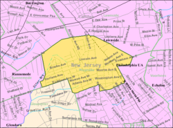
 Census Bureau map of Magnolia, New Jersey |
|
| Coordinates: 39°51′22″N 75°02′11″W / 39.856184°N 75.036471°WCoordinates: 39°51′22″N 75°02′11″W / 39.856184°N 75.036471°W | |
| Country |
|
| State |
|
| County | Camden |
| Incorporated | May 12, 1915 |
| Government | |
| • Type | Borough |
| • Body | Borough Council |
| • Mayor | BettyAnn Cowling-Carson (D, term ends December 31, 2019) |
| • Clerk | John D. Keenan Jr. |
| Area | |
| • Total | 0.968 sq mi (2.507 km2) |
| • Land | 0.968 sq mi (2.507 km2) |
| • Water | 0.000 sq mi (0.000 km2) 0.00% |
| Area rank | 504th of 566 in state 28th of 37 in county |
| Elevation | 79 ft (24 m) |
| Population (2010 Census) | |
| • Total | 4,341 |
| • Estimate (2015) | 4,298 |
| • Rank | 397th of 566 in state 25th of 37 in county |
| • Density | 4,485.3/sq mi (1,731.8/km2) |
| • Density rank | 131st of 566 in state 14th of 37 in county |
| Time zone | Eastern (EST) (UTC-5) |
| • Summer (DST) | Eastern (EDT) (UTC-4) |
| ZIP code | 08049 |
| Area code(s) | 609 and 856 |
| FIPS code | 3400742630 |
| GNIS feature ID | 0885288 |
| Website | www |
Magnolia is a borough in Camden County, New Jersey, United States. As of the 2010 United States Census, the borough's population was 4,341, reflecting a decline of 68 (-1.5%) from the 4,409 counted in the 2000 Census, which had in turn declined by 452 (-9.3%) from the 4,861 counted in the 1990 Census.
Magnolia was incorporated as a borough by an act of the New Jersey Legislature on April 14, 1915, from portions of the now-defunct Centre Township, and parts of Clementon, based on the results of a referendum held on May 12, 1915. The borough was named for magnolia trees that grow in the area.
According to the United States Census Bureau, Magnolia borough had a total area of 0.968 square miles (2.507 km2), all of which was land.
The borough borders Barrington, Gloucester Township, Lawnside, Runnemede and Somerdale.
As of the 2010 United States Census, there were 4,341 people, 1,710 households, and 1,147 families residing in the borough. The population density was 4,485.3 per square mile (1,731.8/km2). There were 1,850 housing units at an average density of 1,911.5 per square mile (738.0/km2). The racial makeup of the borough was 74.71% (3,243) White, 18.27% (793) Black or African American, 0.30% (13) Native American, 1.89% (82) Asian, 0.05% (2) Pacific Islander, 2.21% (96) from other races, and 2.58% (112) from two or more races. Hispanic or Latino of any race were 7.83% (340) of the population.
...
Wikipedia
