Magic Valley
| Magic Valley | |
|---|---|
| Region | |

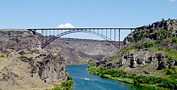
Perrine Bridge spanning the Snake River Canyon at Twin Falls
|
|
 Map of Idaho highlighting counties in the Magic Valley region |
|
| Country |
|
| State |
|
| Largest city |
Twin Falls (pop.: 44,125) |
| Population (2010) | |
| • Total | 185,790 |
| Time zone | Mountain (UTC-7) |
| • Summer (DST) | MDT (UTC-6) |
| Area code(s) | 208 |
The Magic Valley is a region in south-central Idaho consisting of Blaine, Camas, Cassia, Gooding, Jerome, Lincoln, Minidoka and Twin Falls Counties. It is particularly associated with the agricultural region in the Snake River Plain located in the area. The northern Magic Valley region — particularly Blaine and Camas Counties — is also known as the Wood River Valley after the Big Wood River.
According to the 2010 Census the counties of the Magic Valley region had a combined population of 185,790, or nearly 12% of Idaho. Twin Falls is the region's largest city and micropolitan area. Burley is the principal city of the region's other micropolitan area. Other cities include Jerome, Rupert, Gooding, Wendell, Bliss, Hagerman and Hailey.
The name "Magic Valley" is a reference to the construction of Milner and Minidoka Dams and a series of irrigation canal systems (such as the Gooding Milner canal) on the Snake River during the first decade of the 20th century. In a short time these projects "magically" transformed what had been considered a nearly uninhabitable area into some of the most productive farmland in the northwestern U.S. Many cities and towns in the region were founded between 1900 and 1910 as a direct result of these projects.
...
Wikipedia
