Madulain
| Madulain | ||
|---|---|---|
 |
||
|
||
| Coordinates: 46°35′N 9°56′E / 46.583°N 9.933°ECoordinates: 46°35′N 9°56′E / 46.583°N 9.933°E | ||
| Country | Switzerland | |
| Canton | Graubünden | |
| District | Maloja | |
| Area | ||
| • Total | 16.28 km2 (6.29 sq mi) | |
| Elevation | 1,697 m (5,568 ft) | |
| Population (Dec 2015) | ||
| • Total | 229 | |
| • Density | 14/km2 (36/sq mi) | |
| Postal code | 7523 | |
| SFOS number | 3783 | |
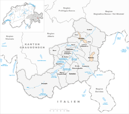
| Surrounded by | Bever, La Punt-Chamues-ch, Pontresina, S-chanf, Zuoz | |
| Website |
www SFSO statistics |
|
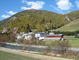
Madulain (![]() [mɐduˈlaɪ̯n] ) is a municipality in the Maloja Region in the Swiss canton of Graubünden.
[mɐduˈlaɪ̯n] ) is a municipality in the Maloja Region in the Swiss canton of Graubünden.
Madulain is first mentioned around 1137-39 as Madulene.
Guardaval Castle was built near the village of Madulain in the 13th century to administer the estates of the Bishop of Chur in the Upper Engadine. In 1409 the Bishop had to pledge the castle to the League of God's House to pay off some of his debts. Under the League, the castle was no longer an administrative center and was abandoned, falling into ruin.
Madulain has an area, (as of the 2004/09 survey) of 16.28 km2 (6.29 sq mi). Of this area, about 30.7% is used for agricultural purposes, while 14.5% is forested. Of the rest of the land, 2.6% is settled (buildings or roads) and 52.2% is unproductive land. In the 2004/09 survey a total of 13 ha (32 acres) or about 0.8% of the total area was covered with buildings, an increase of 6 ha (15 acres) over the 1985 amount. Over the same time period, the amount of recreational space in the municipality increased by 14 ha (35 acres) and is now about 0.98% of the total area. Of the agricultural land, 74 ha (180 acres) is fields and grasslands and 473 ha (1,170 acres) consists of alpine grazing areas. Since 1985 the amount of agricultural land has decreased by 45 ha (110 acres). Over the same time period the amount of forested land has increased by 9 ha (22 acres). Rivers and lakes cover 23 ha (57 acres) in the municipality.
...
Wikipedia


