Madresfield
| Madresfield | |
|---|---|
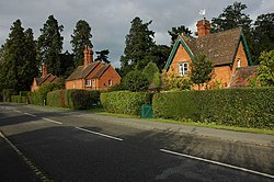
 Estate houses in the village |
|
| Madresfield shown within Worcestershire | |
| OS grid reference | SO804473 |
| Civil parish |
|
| District | |
| Shire county | |
| Region | |
| Country | England |
| Sovereign state | United Kingdom |
| Post town | MALVERN |
| Postcode district | WR13 |
| Police | West Mercia |
| Fire | Hereford and Worcester |
| Ambulance | West Midlands |
| EU Parliament | West Midlands |
| UK Parliament |
|
Madresfield is a village and civil parish in the administrative district of Malvern Hills in the county of Worcestershire, England. It is located about two miles east of Malvern town centre at the foot of the Malvern Hills and is less than two miles from the River Severn. Surrounded by farms and common land, it has a clear view of the entire range of the Malvern Hills, and is part of the informal region referred to as The Malverns.
The name Madresfield possibly derives from 'Mather's Field' (though there are other theories to its origin) and is pronounced "Ma-ders Field" or "Ma-dres Field".
Madresfield is not mentioned in the Domesday Book, as it was part of the manor of Powick.
Madresfield is part of a Church of England parish which includes the neighbouring village of Guarlford. There is a parish church in the village (dedicated to St. Mary the Virgin). There have been three churches, the first a small chapel that was mainly used by the Beauchamps. A second church, built on marshy ground to the designs of Augustus Pugin, was demolished after only twelve years after becoming unsafe. The present church was built on land donated by the Earl Beauchamp and re-used many items from the earlier church. The church, dedicated to St Mary the Virgin, has a refurbished peal of bells which are on the visiting circuit of regional campanologists. The bells were rehung in December 2005 following recasting of 1 and 2 from the scrap metal of the old 4th and tenor and retuning the other bells., The village also has a primary school.
...
Wikipedia

