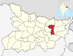
Madhepura district
|
Madhepura district मधेपुरा जिला,ضلع مدھے پورا |
|
|---|---|
| District of Bihar | |
 Location of Madhepura district in Bihar |
|
| Country | India |
| State | Bihar |
| Administrative division | Kosi |
| Headquarters | Madhepura |
| Government | |
| • Lok Sabha constituencies | Madhepura |
| • Assembly seats | Alamnagar, Bihariganj, Singheshwar, Madhepura |
| Area | |
| • Total | 1,787 km2 (690 sq mi) |
| Population (2011) | |
| • Total | 1,994,618 |
| • Density | 1,100/km2 (2,900/sq mi) |
| Demographics | |
| • Literacy | 53.78 per cent |
| • Sex ratio | 914 |
| Major highways | NH 106 |
| Website | Official website |
| Madhepura |
| Ghelardh |
| Singheshwar |
| Gamhariya |
| Shankarpur |
| Kumarkhand |
| Murliganj |
| Gwalpara |
| Bihariganj |
| Udakishunganj |
| Puraini |
| Alamnagar |
| Chousa |
Madhepura district is one of the thirty-eight districts of Bihar state, India, and Madhepura town is the administrative headquarters of this district. Madhepura district is a part of Kosi division.
Madhepura is part of the Mithila region and the people here speak the Maithili language.
Being carved out of Saharsa district, Madhepura got the status of revenue district on 9 May 1981. Prior to that Madhepura was a sub-division under Bhagalpur district with effect from 3 September 1845. Subsequently, it was on 1 April 1954 that Saharsa district was carved out of Bhagalpur district.
Facing the onslaughts of the Kosi river, the history of Madhepura is replet with tales of owes, sorrow and sufferings. Since time immemorial, it has seen several ups and downs perpetuated by Kosi in the form of flood, famine and drought. Flood and drought have remained the regular feature of the area so much so that the then Government had to shift the Court & the Sub-divisional headquarters from Madhepura to Supaul from 1935 to 1938.
There is not any authentic information regarding the origin of Madhepura. Available sources indicate that the name Madhepura was evolved from Gangapur- a village named after Gangadeo, the grand son of King Mithi, who is said to have established state Mithila. It is also said that the village Gangapur was named after King Gangsen of the Sena dynasty.
From 1704 A.D. to 1892, the Kosi river with its diverse courses remained striding the areas right from Forbesganj to Chandeli Karamchand and Raghuvansha Nagar & thereafter submerging itself into the Ganges at Kursela. As Madhepura stands at the centre of Kosi ravine, it was called Madhyapura- a place centrally situated which was subsequently transformed as Madhipura into present Madhepura. Another view is also there as to its naming as the area is said to have been inhabited by the bulk of Madhavas - clan of Lord Krishna, it was termed as Madhavpur which gradually became Madhavpur into Madhepura.
In ancient times, Madhepura remained a part of Anga Desh. It was also governed by Maurya, Shunga, Kanva and Kushan dynasties. It was a part of Mithila Province during Gupta period. The Mauryan Pillar discovered at Kishunganj bears testimony to it. Madhepura remained under the dominance of Bihar rulers during Rajput rule. Present Raibhir village under Singheshwar block was a stronghold of Bhars. During Mugal period Madhepura remained under Sarkar Tirhut.
...
Wikipedia
