Madawaska Highlands
| Opeongo Hills | |
|---|---|

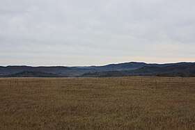
Opeongo Hills near Boulter, Ontario.
|
|
| Highest point | |
| Peak | Unmarked point |
| Elevation | 586 m (1,923 ft) |
| Geography | |
| Country | Canada |
| Province | Eastern Ontario |
| Range coordinates | 45°30′N 77°40′W / 45.500°N 77.667°WCoordinates: 45°30′N 77°40′W / 45.500°N 77.667°W |
The Opeongo Hills (sometimes called the Opeongo Mountains or Madawaska Highlands, particularly for the eastern-most hills) are a range of hills in Southern Ontario, near Algonquin Provincial Park. The hills stretch from Opeongo Lake in Algonquin Park in the west, along the Madawaska and Opeongo Rivers, towards the Opeongo Colonization Road, and extending towards the Deacon Escarpment (north of Killaloe, Ontario in Renfrew County), Bonnechere, Ontario, and Dacre in the east. To the east of the Opeongo Hills lie the Madawaska River valley, the Mississippi River Valley, and the Ottawa-Bonnechere Graben along the Ottawa River. The hills continue into Quebec across the Ottawa River as the Laurentian Highlands and the Laurentian Mountains. Its tallest peak is roughly 7 km northeast of Highway 60. At roughly 586 meters, it is the tallest point in Southern Ontario. The community of Foymount (along former Highway 512, the Opeongo Line) is the highest settlement in Southern Ontario.
The Opeongo Hills are a continuation of the Laurentian Highlands, which extend into Eastern Ontario, towards Gananoque, and across the Ottawa River Valley into Quebec, and the Laurentian Mountains, which continue parallel to the St. Lawrence River, north of Montreal, Trois-Rivières and Quebec City.
...
Wikipedia

