Madagascar subhumid forests
| Madagascar subhumid forests | |
|---|---|

|
|
 |
|
| Ecology | |
| Realm | Afrotropic |
| Biome | Tropical moist broadleaf forest |
| Borders | Madagascar ericoid thickets, Madagascar lowland forests, Madagascar spiny forests, Madagascar succulent woodlands, Madagascar dry deciduous forests |
| Animals | Lac Alaotra bamboo lemur, chameleons |
| Geography | |
| Area | 199,600 km2 (77,100 sq mi) |
| Country | Madagascar |
| Elevation | 600–1,800 metres (2,000–5,900 ft) |
| Coordinates | 18°56′S 47°31′E / 18.933°S 47.517°ECoordinates: 18°56′S 47°31′E / 18.933°S 47.517°E |
| Climate type | Tropical monsoon climate (Am), tropical savanna climate (Aw), humid subtropical climate (Cwa) |
| Conservation | |
| Conservation status | Critical/endangered |
| Global 200 | included |
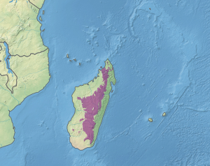
The Madagascar subhumid forests are a tropical moist broadleaf forest ecoregion that covers most of the Central Highlands of the island of Madagascar. They are included in the WWF's Global 200 list of outstanding ecoregions. Most of the original habitats have been lost due to human pressure.
The Madagascar subhumid forests ecoregion extends over most of the Central Highlands, above approximately 800 metres (2,600 ft) elevation on the east and above 600 metres (2,000 ft) meters elevation on the west. Most of that area is now covered by secondary grasslands and agriculture, with forest reduced to fragmented patches. The ecoregion has an area of approximately 199,600 square kilometers (77,100 sq mi). The highlands catch the wet northeast trade winds, while the areas to the south, west, and north lie in the drier rain shadow of the highlands.
The subhumid forests are bounded by the humid Madagascar lowland forests along the coastal strip to the east, by the Madagascar dry deciduous forests to the north, northwest and west, and by the sub-arid Madagascar succulent forests and Madagascar spiny thickets to the southwest and south. In four areas above 1,800–2,000 metres (5,900–6,600 ft) elevation, the subhumid forests yield to the montane Madagascar ericoid thickets.
Montagne d'Ambre near the northern tip of the island, contains a significant pocket of subhumid forest, surrounded at lower elevations by dry deciduous forest, as do Ankaratra, upland near Tsaratanana, Andringitra Massif, Ambohitantely Reserve, and the Ambohijanahary area. The subhumid forests ecoregion also includes the disjunct Analavelona and Isalo massifs to the southwest, surrounded by succulent forests at lower elevations, and wetlands such as Lake Alaotra. The Sambirano region in the northwest is a particular centre of endemism.
...
Wikipedia
