Maaseik
|
Maaseik Mezeik (Limburgs) |
|||
|---|---|---|---|
| Municipality | |||

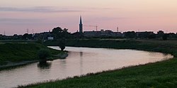
Meuse river near Maaseik
|
|||
|
|||
| Location in Belgium | |||
| Coordinates: 51°06′N 05°48′E / 51.100°N 5.800°ECoordinates: 51°06′N 05°48′E / 51.100°N 5.800°E | |||
| Country | Belgium | ||
| Community | Flemish Community | ||
| Region | Flemish Region | ||
| Province | Limburg | ||
| Arrondissement | Maaseik | ||
| Government | |||
| • Mayor | Jan Creemers (CD&V) | ||
| • Governing party/ies | CD&V, VLD | ||
| Area | |||
| • Total | 76.91 km2 (29.70 sq mi) | ||
| Population (1 January 2016) | |||
| • Total | 25,133 | ||
| • Density | 330/km2 (850/sq mi) | ||
| Postal codes | 3680 | ||
| Area codes | 089 | ||
| Website | www.maaseik.be | ||
Maaseik (Limburgs: Mezeik) is a town and municipality in the Belgian province of Limburg. Both in size (close to 77 km²) as in population (around 25,000 inhabitants, of whom ca. 3,000 non-Belgian), it is the 8th largest municipality in Limburg. The town is the seat of the administrative arrondissement of Maaseik (kieskanton). Internationally, Maaseik is known as the assumed birthplace of the famous Flemish painters Jan and Hubert van Eyck.
The town of Maaseik is located on the left bank of the river Meuse (Dutch: Maas), bordering the Netherlands. For this reason the river is called Grensmaas ('border Meuse') here. Two smaller rivers, the Bosbeek (or Oeterbeek) and the Zanderbeek (or Diepbeek), flow into the Meuse near Maaseik. Because of its location in the Meuse valley, Maaseik has mostly fertile soils. The northwestern part of the municipality is situated on the plain of Bocholt and has less fertile soils.
The Meuse valley at Maaseik is about 4 kilometers wide. Maaseik has mostly been safeguarded of floods by its slightly elevated position on a fluvial terrace. The riverbed has moved eastwards considerably over the centuries and has left several anabranches, meanders and oxbow lakes. An old anabranche of the Meuse (Oude Maasarm) can be seen in Heppeneert, a hamlet south of Maaseik. Deposition of sediments (mainly gravel, loam and clay) occurred on the inner edges of the meanders. For many decades gravel has been extracted from the area, resulting in a multitude of disused gravel pits, which have been mostly redesignated as nature reserves or watersports areas.
...
Wikipedia


