Lyons, New York
| Lyons, New York | |
|---|---|
| Town | |

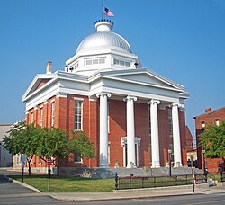
Wayne County Courthouse
|
|
 Location in Wayne County and the state of New York. |
|
| Coordinates: 43°03′35″N 076°59′33″W / 43.05972°N 76.99250°WCoordinates: 43°03′35″N 076°59′33″W / 43.05972°N 76.99250°W | |
| Country | United States |
| State | New York |
| County | Wayne |
| Settled | 1789 |
| Established | March 1, 1811 |
| Government | |
| • Type | Town Board |
| • Supervisor | Brian Manktelow |
| • Clerk | Sal J. Colatarci |
| • Court | Justice Larry D. Hartwell Justice Richard Wunder |
| Area | |
| • Total | 37.6 sq mi (97.4 km2) |
| • Land | 37.5 sq mi (97.1 km2) |
| • Water | 0.1 sq mi (0.3 km2) |
| Elevation | 410 ft (137 m) |
| Population (2010) | |
| • Total | 5,682 |
| • Density | 151.1/sq mi (58.3/km2) |
| Time zone | Eastern (EST) (UTC-5) |
| • Summer (DST) | EDT (UTC-4) |
| ZIP code | 14489 |
| Area code(s) | 315 |
| FIPS code | 36-43962 |
| GNIS feature ID | 0956197 |
| Website | http://lyonstown.com/ |
Lyons is a town in Wayne County, New York, United States. The population was 5,682 at the 2010 census. It is named after Lyon, France.
The Town of Lyons is in the south-central part of the county and contains a hamlet also named Lyons, formerly a village. It is located on the Erie Canal, and is the county seat of Wayne County.
The area was part of the Pulteney Estate. Settlement began around 1789. The region was originally known as "The Forks." The Town of Lyons was formed from the Town of Sodus in 1811. The Erie Canal was completed as far as Lyons by 1821.
In 1825, the size of the town was reduced upon the formation of the Town of Arcadia.
According to the United States Census Bureau, the town has a total area of 37.6 square miles (97.4 km²), of which, 37.5 square miles (97.1 km²) of it is land and 0.1 square miles (0.3 km²) of it (0.32%) is water.
New York State Route 14 and New York State Route 31 intersect in the hamlet of Lyons.
As of the census of 2010, there were 5,682 people, 2,206 households, and 1,389 families residing in the town. The population density was 151.1 people per square mile (58.3/km²). The racial makeup of the town was 87.1% White, 8.1% Black or African American, 0.4% Native American, 0.2% Asian, 0.0% Pacific Islander, 1.7% from other races, and 2.5% from two or more races. Hispanic or Latino of any race were 4.7% of the population.
...
Wikipedia
