Lykens, Pennsylvania
| Lykens, Pennsylvania | |
|---|---|
| Borough | |
 |
|
 Location in Dauphin County and state of Pennsylvania. |
|
| Coordinates: 40°34′01″N 76°42′09″W / 40.56694°N 76.70250°WCoordinates: 40°34′01″N 76°42′09″W / 40.56694°N 76.70250°W | |
| Country | United States |
| State | Pennsylvania |
| County | Dauphin |
| Settled | 1848 |
| Incorporated | 1872 |
| Government | |
| • Type | Borough Council |
| Area | |
| • Total | 1.22 sq mi (3.16 km2) |
| • Land | 1.22 sq mi (3.16 km2) |
| • Water | 0.00 sq mi (0.00 km2) |
| Elevation | 705 ft (215 m) |
| Population (2010) | |
| • Total | 1,779 |
| • Estimate (2016) | 1,751 |
| • Density | 1,435.25/sq mi (554.33/km2) |
| Time zone | Eastern (EST) (UTC-5) |
| • Summer (DST) | EDT (UTC-4) |
| ZIP code | 17048 |
| Area code(s) | 717 Exchange: 453 |
| FIPS code | 42-45592 |
| Website | www |
Lykens is a borough in Dauphin County, Pennsylvania. Anthracite coal mining sustained the people who numbered 2,762 in 1900 and 2,943 in 1910. The population was 1,779 at the 2010 census.
Lykens is part of the Harrisburg–Carlisle Metropolitan Statistical Area.
Lykens was laid out in 1848. The borough was named for Andrew Lycan.
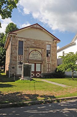
The GAR Building was listed on the National Register of Historic Places in 1986.
Lykens is located in northeastern Dauphin County at 40°34′01″N 76°42′09″W / 40.566850°N 76.702585°W, in the valley of Wiconisco Creek, between Short Mountain and Big Lick Mountain to the north, and Berry Mountain to the south. U.S. Route 209 passes through the borough, leading northeast 29 miles (47 km) to Pottsville and west 14 miles (23 km) to Millersburg on the Susquehanna River.
According to the United States Census Bureau, the borough has a total area of 1.2 square miles (3.2 km2), all of it land.
...
Wikipedia
