Luz (Santa Cruz da Graciosa)
| Luz | ||
| Civil Parish | ||
|
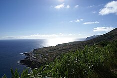
The most southern community in Luz, Carapacho, as seen from the Ponta da Restinga
|
||
|
||
| Official name: Freguesia da Luz | ||
| Name origin: Portuguese for light; derived from the religious parish's name Nossa Senhora da Luz | ||
| Country | ||
|---|---|---|
| Autonomous Region | ||
| Island | Graciosa | |
| Municipality | Santa Cruz da Graciosa | |
| Localities | Alto do Sul, Fajã da Folga, Folga, Carapacho, Luz, Pedras Brancas | |
| Center | Luz | |
| - elevation | 88 m (289 ft) | |
| - coordinates | 39°1′18″N 27°59′23″W / 39.02167°N 27.98972°WCoordinates: 39°1′18″N 27°59′23″W / 39.02167°N 27.98972°W | |
| Highest point | Pico Timão | |
| - elevation | 398 m (1,306 ft) | |
| - coordinates | 39°2′15″N 28°0′30″W / 39.03750°N 28.00833°W | |
| Lowest point | Sea level | |
| - location | Atlantic Ocean | |
| - elevation | 0 m (0 ft) | |
| Area | 11.70 km2 (5 sq mi) | |
| - urban | 1.11 km2 (0 sq mi) | |
| Population | 683 (2011) | |
| Density | 58/km2 (150/sq mi) | |
| Settlement | fl.1600 | |
| - Parish | c.1601 | |
| - Civil Parish | c.1867 | |
| LAU | Junta Freguesia | |
| - location | Rua 6 Janeiro | |
| - coordinates | 39°1′19″N 27°59′26″W / 39.02194°N 27.99056°W | |
| President Junta | Manuel António Silva Ataíde Silveira (PPD-PSD) | |
| Timezone | Azores (UTC-1) | |
| - summer (DST) | Azores (UTC0) | |
| Postal Zone | 9880-154 | |
| Area Code & Prefix | (+351) 292 XXX-XXXX | |
| Patron Saint | Nossa Senhora de Luz | |
| Website: cm-graciosa.azoresdigital.pt | ||
Luz is a civil parish in the municipality of Santa Cruz da Graciosa on the island of Graciosa in the Portuguese Azores. The population in 2011 was 683, in an area of 11.70 km².
...
Wikipedia


