Lushnja
| Lushnjë | ||
|---|---|---|
| Municipality | ||

City Center
|
||
|
||
| Coordinates: 40°56′N 19°42′E / 40.933°N 19.700°ECoordinates: 40°56′N 19°42′E / 40.933°N 19.700°E | ||
| Country |
|
|
| County | Fier | |
| Government | ||
| • Mayor | Fatos Tushe (SP) | |
| Area | ||
| • Municipality | 372.72 km2 (143.91 sq mi) | |
| Elevation | 9 m (30 ft) | |
| Population (2011) | ||
| • Municipality | 83,659 | |
| • Municipality density | 220/km2 (580/sq mi) | |
| • Administrative Unit | 31,105 | |
| Time zone | CET (UTC+1) | |
| • Summer (DST) | CEST (UTC+2) | |
| Postal Code | 9001 | |
| Area Code | (0)35 | |
| Vehicle registration | AL | |
| Website | Official Website | |
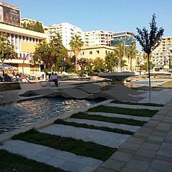
Lushnjë (Albanian pronunciation: [ˈluʃɲə], Turkish: Leşne; in Lushnjë's own dialect Lushnje [ˈluʃɲe]) is a town and a municipality in west-central Albania. It is located in the County of Fier. The municipality was formed at the 2015 local government reform by the merger of the former municipalities Allkaj, Ballagat, Bubullimë, Dushk, Fier-Shegan, Golem, Hysgjokaj, Karbunarë, Kolonjë, Krutje and Lushnjë, that became municipal units. The seat of the municipality is the town Lushnjë. The total population is 83,659 (2011 census), in a total area of 372.72 km2. The population of the former municipality at the 2011 census was 31,105.
In January 1920, Lushnjë was a provisional capital of Albania and the place of the Congress of Lushnjë. Chieftains of Albania assembled in the town and declared Tirana first a provisional and then the definitive capital of Albania.
3 km away from Lushnjë is the Savra Field. This field is on the Lushnjë-Fier road. Here the first battle between Principality of Zeta and Ottoman Empire occurred in 1385 (the Battle of Savra). In this battle Balsha II was killed. Along with Fier, Lushnjë was the main district of the concentration camps during the Communist Regime; some of the camps included the villages of Savër, Gradishtë, Bedat, Gjazë, Rrapëz, Plug, etc.
...
Wikipedia


