Lusby, Maryland
| Lusby, Maryland | |
|---|---|
| Census-designated place | |
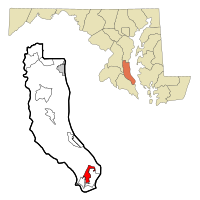
 Location of Lusby, Maryland |
|
| Coordinates: 38°21′13″N 76°26′12″W / 38.35361°N 76.43667°WCoordinates: 38°21′13″N 76°26′12″W / 38.35361°N 76.43667°W | |
| Country | United States |
| State | Maryland |
| County | Calvert |
| Area | |
| • Total | 3.7 sq mi (9.5 km2) |
| • Land | 3.5 sq mi (9.1 km2) |
| • Water | 0.2 sq mi (0.4 km2) |
| Elevation | 105 ft (32 m) |
| Population (2010) | |
| • Total | 1,835 |
| • Density | 522/sq mi (201.6/km2) |
| Time zone | Eastern (EST) (UTC-5) |
| • Summer (DST) | EDT (UTC-4) |
| ZIP code | 20657 |
| Area code(s) | 410 |
| FIPS code | 24-48800 |
| GNIS feature ID | 0590708 |
Lusby is an unincorporated community and census-designated place (CDP) in Calvert County, Maryland, United States. The population of the CDP was 1,835 at the 2010 census. Residents of the Chesapeake Ranch Estates and Drum Point communities also use the Lusby ZIP code designation.
Lusby is located near the southern end of Calvert County at 38°21′13″N 76°26′12″W / 38.35361°N 76.43667°W (38.353555, -76.436615). It is bordered to the southwest by Solomons, a tourist resort town, to the south by Drum Point (across tidal Mill Creek), and to the southeast by Chesapeake Ranch Estates, a large community governed by a homeowners' association.
Dominion Cove Point LNG, one of the nation's largest liquefied natural gas import facilities, is located just northeast of Lusby, and the Calvert Cliffs Nuclear Power Plant is 5 miles (8 km) to the north. Maryland Routes 2 and 4 run along the western edge of Lusby, leading south to the Patuxent River Naval Air Station and north to Andrews Air Force Base and the Washington, D.C., and Annapolis areas.
...
Wikipedia
