Loyalsockville, Pennsylvania
| Upper Fairfield Township, Lycoming County, Pennsylvania |
|
|---|---|
| Township | |

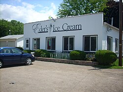
Eder's Ice Cream in Upper Fairfield Township
|
|
 Map of Lycoming County, Pennsylvania highlighting Upper Fairfield Township |
|
 Map of Lycoming County, Pennsylvania |
|
| Coordinates: 41°19′10″N 76°51′41″W / 41.31944°N 76.86139°WCoordinates: 41°19′10″N 76°51′41″W / 41.31944°N 76.86139°W | |
| Country | United States |
| State | Pennsylvania |
| County | Lycoming |
| Settled | 1800 |
| Incorporated | 1851 |
| Area | |
| • Total | 18.2 sq mi (47.2 km2) |
| • Land | 18.1 sq mi (46.9 km2) |
| • Water | 0.1 sq mi (0.3 km2) |
| Elevation | 896 ft (273 m) |
| Population (2010) | |
| • Total | 10,707 |
| • Estimate (2016) | 1,805 |
| • Density | 102.4/sq mi (39.5/km2) |
| Time zone | Eastern (EST) (UTC-5) |
| • Summer (DST) | EDT (UTC-4) |
| FIPS code | 42-081-79024 |
| GNIS feature ID | 1216774 |
Upper Fairfield Township is a township in Lycoming County, Pennsylvania, United States. The population was 1,854 at the 2000 census. It is part of the Williamsport, Pennsylvania Metropolitan Statistical Area.
The history of Upper Fairfield Township begins in 1851 when some dissatisfied citizens of the southern portion of Fairfield Township asked to be separated from the neighbors to the north. The citizens of the northern portion were strongly against division, but the township was divided against their wishes on September 12, 1851.
Upper Fairfield Township was called Pollock Township during its first two years of existence. It was named for Judge James Pollock, president of the district court that ordered the township to be divided, and a controversial figure at the time. Since the citizens of Upper Fairfield Township opposed division, they were disturbed by its name. Following a petition to the court that the township's name be changed, an act of the Pennsylvania General Assembly changed the name to Upper Fairfield Township on January 29, 1853.
Upper Fairfield Township is bordered by Plunketts Creek Township to the north, Mill Creek Township to the east, Muncy Township to the southeast, Fairfield Township to the south, and Loyalsock and Eldred Townships to the west. Loyalsock Creek is the boundary line between Upper Fairfield and Loyalsock Townships as well as Upper Fairfield and Eldred.As the crow flies, Lycoming County is about 130 miles (209 km) northwest of Philadelphia and 165 miles (266 km) east-northeast of Pittsburgh.
...
Wikipedia
