Lower Towamensing Township, Carbon County, Pennsylvania
| Lower Towamensing Township | |
| Settlement | |
| Country | United States |
|---|---|
| State | Pennsylvania |
| County | Carbon |
| Elevation | 449 ft (136.9 m) |
| Coordinates | 40°48′00″N 75°37′31″W / 40.80000°N 75.62528°WCoordinates: 40°48′00″N 75°37′31″W / 40.80000°N 75.62528°W |
| Area | 21.3 sq mi (55.2 km2) |
| - land | 21.2 sq mi (55 km2) |
| - water | 0.1 sq mi (0 km2), 0.47% |
| Population | 3,228 (2010) |
| Density | 151.9/sq mi (58.6/km2) |
| Timezone | EST (UTC-5) |
| - summer (DST) | EDT (UTC-4) |
| Area code | 610 |
|
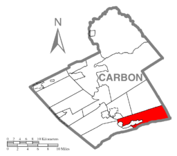
Location of Lower Towamensing Township in Carbon County
|
|
|
Website: lowertowtwp |
|
Lower Towamensing Township is a township in Carbon County, Pennsylvania, United States. The Delaware Peoples name is eponymous and was once applied by the natives to the whole region of Carbon County and bits of the Poconos to the north (Luzerne County) and to Schuylkill County (southwest). The population was 3,228 at the 2010 census.
The Aquashicola Volunteer Fire Department has provided service in the township for many years. The Little Gap Covered Bridge was added to the National Register of Historic Places in 1980.
The township is in southeastern Carbon County and is bordered by Northampton County to the south and Monroe County to the east. According to the United States Census Bureau, the township has a total area of 21.30 square miles (55.17 km2), of which 21.25 square miles (55.05 km2) is land and 0.05 square miles (0.12 km2), or 0.21%, is water. It is drained by tributaries (Aquashicola Creek, etc.) of the Lehigh River which separates it from East Penn Township, and its southern geographic boundary is Blue Mountain.
Villages in the township include Aquashicola (locally pronounced "ack-wa-SHIK-la"), Christian Corner, Hazard, and Little Gap (which hosts the Blue Mountain Ski Area). Pennsylvania Route 248 passes through the westernmost parts of the township, following the Lehigh River, and connects Lehighton to the northwest with the Allentown–Bethlehem area to south, as well as having nearby interchanges in Palmerton and Bowmanstown.
...
Wikipedia


