Lower Oxford Township, Pennsylvania
| Lower Oxford Township | |
| Township | |
| Country | United States |
|---|---|
| State | Pennsylvania |
| County | Chester |
| Elevation | 525 ft (160.0 m) |
| Coordinates | 39°48′27″N 75°58′16″W / 39.80750°N 75.97111°WCoordinates: 39°48′27″N 75°58′16″W / 39.80750°N 75.97111°W |
| Area | 18.5 sq mi (47.9 km2) |
| - land | 18.2 sq mi (47 km2) |
| - water | 0.3 sq mi (1 km2), 1.62% |
| Population | 5,200 (2010) |
| Density | 285.7/sq mi (110.3/km2) |
| Timezone | EST (UTC-5) |
| - summer (DST) | EDT (UTC-4) |
| Area code | 610 |
|
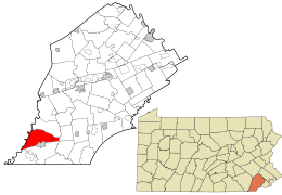
Location in Chester County and the state of Pennsylvania.
|
|
|
Location of Pennsylvania in the United States
|
|
|
Website: www |
|
Lower Oxford Township is a township in Chester County, Pennsylvania, United States. The population was 5,200 at the 2010 census. Lincoln University, a historically black university, is located in the township.
The Hopewell Historic District and Pine Grove Covered Bridge are listed on the National Register of Historic Places. The township is named after Oxford, England.
The township was also acted as an early genesis point and catalyst for large Irish and especially Scotch-Irish settlement and expansion into Chester County and points west in Pennsylvania. Part of the township was originally disputed territory between Pennsylvania and Maryland, resolved eventually by the Mason–Dixon line. One third of the township formed part of the northern section of Susquehanna Manor later known as New Connaught, a large settlement tract established by Maryland and named after the western province of Connacht in Ireland that courted Irish settlement into the area. The township was also originally part of neighboring Londonderry Township, named after Londonderry, Ireland, and settled by Irish (primarily Scotch-Irish) settlers entering Pennsylvania.
According to the United States Census Bureau, the township has a total area of 18.5 square miles (48 km2), of which 18.2 square miles (47 km2) is land and 0.3 square miles (0.78 km2), or 1.83%, is water.
At the 2010 census, the township was 53.1% non-Hispanic White, 35.1% Black or African American, 0.3% Native American, 0.3% Asian, 0.1% Native Hawaiian or other Pacific Islander, and 2.3% were two or more races. 10.6% of the population were of Hispanic or Latino ancestry.
...
Wikipedia


