Lower Milford Township, Pennsylvania
| Lower Milford Township | |
| Township | |
| Country | United States |
|---|---|
| State | Pennsylvania |
| County | Lehigh |
| Elevation | 650 ft (198.1 m) |
| Coordinates | 40°30′30″N 75°27′29″W / 40.50833°N 75.45806°WCoordinates: 40°30′30″N 75°27′29″W / 40.50833°N 75.45806°W |
| Area | 19.6 sq mi (50.8 km2) |
| - land | 19.6 sq mi (51 km2) |
| - water | 0.0 sq mi (0 km2), 0% |
| Population | 3,617 (2000) |
| Density | 184.1/sq mi (71.1/km2) |
| Timezone | EST (UTC-5) |
| - summer (DST) | EDT (UTC-4) |
| Area code | 610 and 215 |
|
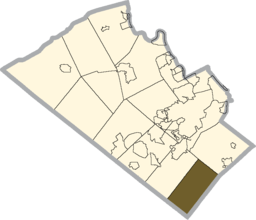
Location of Lower Milford Township in Lehigh County
|
|
|
Website: www |
|
Lower Milford Township is a township in Lehigh County, Pennsylvania, in the United States. It is a suburb of Allentown, Pennsylvania, in the Lehigh Valley region of the state.
The population of Lower Milford Township was 3,775 at the 2010 census.
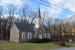
The Dillingersville Union School and Church was added to the National Register of Historic Places in 1978.
According to the United States Census Bureau, the township has a total area of 19.6 square miles (50.9 km²), all of it land. Its villages include Corning (also in Upper Milford Township,) Dillingersville, Hosensack, Kraussdale, Limeport (also in Upper Saucon Township,) and Zionsville (also in Upper Milford Township.)
The township is located in the Delaware watershed. The Saucon Creek begins in Lower Milford and drains part of it into the Lehigh River. Lower Milford is also the source of three tributary creeks of the Perkiomen Creek, which drains to the Schuylkill River: Hosensack Creek (which starts near the source of the Saucon,) Unami Creek, and Macoby Creek. The majority of the township is mountainous and is located in the South Mountains and on Mill Hill to the south and east of the Hosensack Valley.
As of the census of 2000, there were 3,617 people, 1,277 households, and 1,039 families residing in the township. The population density was 184.1 people per square mile (71.1/km²). There were 1,308 housing units at an average density of 66.6/sq mi (25.7/km²). The racial makeup of the township was 98.09% White, 0.17% African American, 0.25% Native American, 0.55% Asian, 0.11% from other races, and 0.83% from two or more races. Hispanic or Latino of any race were 0.69% of the population.
...
Wikipedia


