Lossiemouth
Lossiemouth
|
|
|---|---|
 |
|
| Lossiemouth shown within Moray | |
| Population | 6,803 |
| OS grid reference | NJ235705 |
| Civil parish |
|
| Council area | |
| Lieutenancy area |
|
| Country | Scotland |
| Sovereign state | United Kingdom |
| Post town | LOSSIEMOUTH |
| Postcode district | IV31 6xx |
| Dialling code | 01343 |
| Police | Scottish |
| Fire | Scottish |
| Ambulance | Scottish |
| EU Parliament | Scotland |
| UK Parliament | |
| Scottish Parliament | |
| Website | www |
Lossiemouth (Scottish Gaelic: Inbhir Losaidh) is a town in Moray, Scotland. Originally the port belonging to Elgin, it became an important fishing town. Although there has been over a 1,000 years of settlement in the area, the present day town was formed over the past 250 years and consists of four separate communities that eventually merged into one. From 1890 - 1975 it was a police burgh as Lossiemouth and Branderburgh.
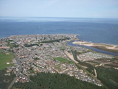
Stotfield, the first significant settlement (discounting Kinneddar which has now disappeared), lies to the north west of the town. Next was the Seatown - a small area between the river and the canal inholding of 52 houses, 51 of which are the historic fisher cottages. Following the decision to build a new harbour on the River Lossie, the 18th Century planned town of Lossiemouth, built on a grid system, was established on the low ground below the Coulard Hill. Branderburgh formed the final development during the 19th Century. This part of the town developed entirely as a result of the new harbour with its two basins and eventually covered the entire Coulard Hill and providing the town's impressive profile when seen from afar.
Although the Romans never conquered the peoples of the North of Scotland, they made several journeys to the Moray Firth coast. Suspected Roman forts have been discovered at Thomshill, near Elgin and at Easter Galcantray, Cawdor, Nairnshire and also a suspected marching camp at Wester Alves, Moray. The Greco-Roman astronomer and geographer, Claudius Ptolemaeus, generally known as Ptolemy (c. 90 – c. 168), describes in chapter 2 of his Geographa entitled Albion Island of Britannia the mouth of the River Lossie as ostium Loxa Fluvius. Settlement in this area has a long history. St Gervadius, a Celtic hermit inhabited a cave overlooking the entrance to the sea loch, Loch Spynie. In his time, the River Lossie entered the loch further to the south, near Inchbroom. The rocky promontory is recorded in the Chartulary of Moray as Holyman's Head and it is said that Gervadius (St Gerardine as he became known in later times) would walk around the headland with a flaming torch to warn ships away from the dangerous rocks. Even today the Halliman Skerries retain the reference to St Gervadius. He died in 934 AD and his cave became a place of pilgrimage right up to the 16th Century. The cave was eventually quarried out.
...
Wikipedia

