Longstreet, Louisiana
| Longstreet, Louisiana | |
|---|---|
| Village | |

Longstreet Town Hall
|
|
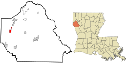
 Location in DeSoto Parish and the state of Louisiana. |
|
 Location of Louisiana in the United States |
|
| Coordinates: 32°05′49″N 93°57′01″W / 32.09694°N 93.95028°WCoordinates: 32°05′49″N 93°57′01″W / 32.09694°N 93.95028°W | |
| Country | United States |
| State | Louisiana |
| Parish | DeSoto |
| Area | |
| • Total | 2.07 sq mi (5.37 km2) |
| • Land | 2.05 sq mi (5.31 km2) |
| • Water | 0.02 sq mi (0.06 km2) |
| Elevation | 322 ft (98 m) |
| Population (2010) | |
| • Total | 157 |
| • Estimate (2016) | 158 |
| • Density | 77.04/sq mi (29.75/km2) |
| Time zone | CST (UTC-6) |
| • Summer (DST) | CDT (UTC-5) |
| Area code(s) | 318 |
| FIPS code | 22-45460 |
Longstreet is a village in DeSoto Parish, Louisiana, United States. The population was 157 at the 2010 census. It is part of the Shreveport–Bossier City Metropolitan Statistical Area.
Longstreet is named for Confederate General James Longstreet.
Longstreet is the location of Bagley Farms, owned in part by Larry Bagley, incoming Republican member of the Louisiana House of Representatives for District 7, which includes Desoto Parish.
Longstreet is located in western DeSoto Parish at 32°5′49″N 93°57′1″W / 32.09694°N 93.95028°W (32.096934, -93.950306).Louisiana Highway 5 passes through the town, leading north 7 miles (11 km) to Keachi and south 9 miles (14 km) to Logansport.
According to the United States Census Bureau, the village of Longstreet has a total area of 2.1 square miles (5.4 km2), of which 0.02 square miles (0.06 km2), or 1.08%, is water.
...
Wikipedia
