Longfield and New Barn
| Longfield | |
|---|---|
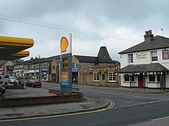
 Station Road showing oast houses converted into shops |
|
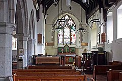
 Interior of parish church |
|
| Longfield shown within Kent | |
| Population | 4,919 (civil parish 2011) |
| OS grid reference | TQ604688 |
| Civil parish | |
| District | |
| Shire county | |
| Region | |
| Country | England |
| Sovereign state | United Kingdom |
| Post town | Longfield |
| Postcode district | DA3 |
| Dialling code | 01474 |
| Police | Kent |
| Fire | Kent |
| Ambulance | South East Coast |
| EU Parliament | South East England |
| UK Parliament | |
Longfield is a village and civil parish in the Dartford Borough of Kent, England. It borders the Sevenoaks District. It is located south west of Gravesend. It contains several shops, a pub, a 14th-century church and is recorded in the Domesday Book and Anglo-Saxon charters of 964-995.
The place in Kent is recorded as Langanfelda in the Saxon Charters of 964-995, and as Langafel in the Domesday Book of 1086.
It had been proposed by town planner Patrick Abercrombie as part of the Greater London Plan in the mid-1940s to build a new town in the Longfield area, however other satellite areas around London were selected instead.
Longfield and New Barn is a civil parish named after the adjacent villages it covers, the eastern part being New Barn, it also covers the smaller settlement, the neighbourhood of Longfield Hill. Longfield is the ancient village, situated on the road between Dartford and Meopham; the historic church there is dedicated to St Mary Magdalene. New Barn is larger in population than Longfield, although has little in the way of services, being a comparatively recent development and purely residential in nature.
Longfield is four miles south east of Dartford and near Gravesend. It is a linear development that is partly contiguous with the village of Hartley immediately to the south.
The whole civil parish gently slopes from southeast and south to north. Elevations range from 92m AOD in the southwest of the developed area of New Barn in the east which is on a wide rise, to 45m AOD in and around the chalk pit just west of Longfield across the largely disused HS1 south-of-London link railway line towards Southfleet (just north of the village). Just above this is the tiny settlement, a farmed area named Pinden, to the south, however before this on the road towards London is another named community, no more than a row of cottages on the road named Whitehill.
...
Wikipedia

